The Cherub Gate Historical Marker, New York City

Cherub Gate at Trinity Church, New York City

A cherub decorates the back entrance of Trinity Church. The cherub originally adorned the St. Mary-le-Bow church which was located in London’s East End. This church was designed and built by Christopher Wren. It was completed in 1680 but was destroyed during the German Blitz in May 1941 during World War II.

Trinity Church was the sister church to St. Mary-le-Bow and pledged $50,000 to the London congregation to rebuild the parish. The cherub had been found in the rubble of the destroyed church. After the London church was rebuilt around 1963-1964, the cherub was presented to Trinity Church.

Historical Marker Inscription

The cherub above is a gift to Trinity Church from the Church of St. Mary le Bow in London which was designed by Sir Christopher Wren in 1680 and was destroyed in an air raid on May 10, 1941. The cherub survived the bombing and was presented to Trinity Church on June 11, 1964

Location

40° 42’ 30.492” N, 74° 0’ 45.180” W

78 Trinity Pl, New York, NY  10038, United States

New Mexico Historic Women Marker Initiative, Santa Fe, New Mexico

New Mexico Historic Women Marker Initiative Historical Marker

The Historic Women Marker Initiative of 2007 had a goal of providing information on important New Mexican women on a portion of the state’s Official Scenic Historic Markers. Before the Initiative, few markers mentioned women.

The initial phase of the project started with 75 markers and was concluded in 2010. An additional 10 were added in 2015, and another 25 are planned to be installed to bring the number to 100.

The program received additional funding in 2022.

Historical Marker Inscription

The New Mexico Historic Women Marker Initiative was founded in 2005 by members of the New Mexico Women’s Forum in a statewide effort to recognize women’s contributions to New Mexico history on the state’s Official Scenic Historic Markers. The Initiative ensures that women’s diverse histories will be remembered and told, and will inspire and provide a guide for future generations. The 2006 Legislature funded the project.

Location

35° 49’ 31.020” N, 105° 58’ 41.592” W
W Frontage Rd, Santa Fe, NM  87506, United States

Birthplace of Columbia University Historical Marker, New York City

Columbia University Historical Marker, New York City, NY

Columbia University began as an all-boys school in 1754 in New York City’s lower Manhattan area. It was originally called King’s College and was created via a royal charter granted by Great Britain’s King George II. The first class was held in a schoolhouse that was part of Trinity Church.

Many of the students of King’s College went on to illustrious careers. These include Alexander Hamilton, John Jay and Robert R. Livingston.

During the American Revolution, classes were suspended from 1776 to 1783.  In 1784, King’s College changed its name to Columbia College. In 1857, the college moved from Park Place to Madison Avenue. It was moved once again in 1896 to its current location in Morningside Heights. It was also renamed again to Columbia University. The university started admitting women in 1983.

Trinity Church, New York City, NY

Historical Marker Inscription

In 1752 Trinity Church gave a grant of land for a new college.

On July 17, 1754, the first class of King’s College, which was to become Columbia University, met in the schoolhouse of Trinity Church located across this street.

The charter for the college was granted on October 31, 1754, during the reign of King George II.

Location

40° 42’ 28.458” N, 74° 0’ 44.930” W

75 Broadway, New York, NY  10006, United States

Roger Wolcott Toll Historical Marker, Estes Park, Colorado

Roger Wolcott Toll Historical Marker, Estes Park, Colorado

Born on October 17, 1883, in Denver, Colorado, Roger Toll was an early employee of the National Park Service. He initially served as the superintendent of Mount Ranier National Park. Toll was appointed to the position by the first National Park Service director, Stephen Mather. He would also go on to serve in the same position at Rocky Mountain and Yellowstone National Parks.

Toll was instrumental in doing investigations and creating reports on potential new national parks, monuments and boundary extensions. Some of these recommendations included Joshua Tree, Death Valley, the Everglades and Big Bend. He also worked on a commission that included George Wright to investigate creating some protected areas along the Mexican-American border.

Wright and Toll were sadly killed in a car accident near Deming, New Mexico, on February 25, 1936. They were on their way to investigate the Ajo Mountains in Arizona.

Historical Marker Inscription

The mountain index on this rock is a memorial to
Roger Wolcott Toll
Superintendent of Mount Rainer National Park 1919-1921 *** of Rocky Mountain National Park 1921-1928 of Yellowstone National Park 1929-1935

Civil Engineer ** Naturalist Mountaineer *** Whose love of the high country was manifested by helping to make it more accessible for you and your friends

Location

40° 24.861′ N, 105° 43.44′

Near Estes Park, Colorado

Lake Bonneville Historical Marker, Malta Idaho

Lake Bonneville Historical Marker, Malta, Idaho

Lake Bonneville was a lake that existed between 30,000 and 13,000 years ago. At its largest, the lake stretched for nearly 20,000 square miles, covering parts of western Utah and eastern parts of Idaho and Nevada. The lake filled up a depression that was located in the Great Basin.

Lake Bonneville had a depth of over 1,000 feet and was approximately 325 miles long by 135 miles wide. During the Ice Age, the fresh water lake was fed by rain, streams, glacier meltwater and rivers.

About 16,000 years ago, the climate became warmer and dryer, and the lake levels began decreasing. Within 2,000 years, the lake decreased to about the size of the Great Salt Lake.

Only a few remnants remain of this great lake, including Salt Lake.

Historical Marker Inscription

20,000 years ago, this land was under water. Not far to the north, you can see the old shore of Lake Bonneville.

Formed in a basin from which no river reached the ocean, this became the largest lake in North America. Finally the lake rose high enough to overflow into the Snake River. Then after the climate got drier, and the great basin of Utah and Nevada became mostly a desert, the lake receded. Salt Lake and two other remnants are all that are left of this old 20,000 square mile lake.

Text prepared by The Idaho Historical Society

Marker Made & Installed by Idaho Transportation Department

Location

42° 4’ 22.820” N, 112° 54’ 18.792” W

Malta, ID  83342, United States

St. Paul’s Chapel Historical Marker, New York City, NY

St. Paul's Chapel Historical Marker New York City

St. Paul’s Chapel was built between 1764 and 1766 and officially opened in 1766. It was established as an outreach center for Trinity Church’s growing congregation. The Great Fire of 1776 destroyed the original Trinity Church, but the chapel survived. The congregation made this their main prayer spot, with congregants including George Washington, who stopped here after his inauguration as president. This is the only surviving Colonial-era church in the city.

Located near the World Trade Center, the chapel survived the attacks on September 11, 2001, and was a place of respite for first responders.

St. Paul's Chapel New York City, NY

Historical Marker Inscription

Landmarks of New York

St. Paul’s Chapel

This famous example of Georgian architecture built 1764-1766, with spire and portico added 1794-1796, is the only church structure surviving the Colonial era of New York City. The design by Thomas McBean closely followed that of St. Martin. In the fields by James Gibbs, President Washington was a regular attendant following his inauguration in 1789 when New York was the national capital.

Place erected 1997 by
The New York Community Trust

Location

40° 42’ 40.302” N, 74° 0’ 31.390” W

214 Broadway, New York, NY  10038, United States

Casa de Armijo Historical Markers, Albuquerque, New Mexico

Old Town Cafe Casa de Armijo Historical Marker

Casa Armijo was built by El Colorado Don Juan Nepomuceno Armijo in 1706.  It was later sold to Ambrosio Armijo. One of the first homes in Old Town, the large adobe hacienda sits in the plaza in Old Town Albuquerque.

Throughout its years, the home has been used for a variety of purposes. During the earliest parts of the settlement of the area, it was used as a fort. Over the years, the location was under different flags: Spanish, Mexican, Confederate, Union and, finally, the United States.

Later, the family turned it into a trading post. In 1931, the location was turned into La Placita Dining Rooms, a restaurant with a tree growing in its dining room. The building was recently sold and turned into Old Town Cafe. The current owner, Michelle La Meres, is a descendant of the Armijo family.

Historical Marker Inscription

(Located on front of the building)

Old Town Cafe

Casa de Armijo

Built in 1706 and occupied for many generations by the Armijo family who were prominent in local history. This hacienda was gay with social life.

During the turmoil of the early settlement the Mexican, Spanish and American Civil War occupation it was used as a fort and a refuge.

Later, still occupied by the Armijo family, portions were used as an early trading post.

In 1930 it was restored from a ruin to its present condition and remodeled in conformity with its old character.

(Located on side of the building)

Casa de Armijo Historical Marker Old Town Albuquerque
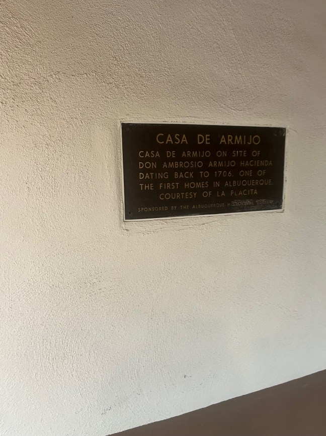
Casa de Armijo on site of Don Ambrosio Armijo hacienda dating back to 1706. One of the first homes in Albuquerque.

Courtesy of La Placita

Sponsored by The Albuquerque Historical Society.

Location

35° 5’ 44.920” N, 106° 40’ 9.822” W
204 San Felipe St NW, Albuquerque, NM  87104, United States

Tarryall Diggings, Jefferson, Colorado Historical Marker

Tarryall Diggings Historical Marker in Colorado

Near Jefferson, located in Park County, Colorado, is the ghost town of Tarryall. It was once known as Tarryall City and was a town created by the gold rush. The town was founded in 1859 and was in existence for four years.

Apparently, the name came from when a group of miners that included William J. Holman and Earl Hamilton stumbled across a stream in South Park looking for gold. The group was exhausted and wanted to “tarry here”. Another member responded, “Yes, we’ll tarry all.” And the name was born. Soon, it also became clear that the stream was filled with gold.

The belief that there was abundant gold in the area encouraged miners to head out to this area of South Park. The town of Tarryall City was created on one side of the stream, and Hamilton was built on the other. The town at its height had approximately 6,000 people. Around $2 million in gold value at the time was collected from the Tarryall Diggings. Even today, visitors can find well over 11,000 mines that were once active in the area.

However, by the end of 1861, Tarryall City and its neighbor Hamilton had quickly declined. By 1867, they were virtually ghost towns.

Historical Marker Description

This memorial is the property of the State of Colorado

Extending up the creek to the mountains were the
Tarryall Diggings
Discovered in July, 1859. Towns of Hamilton and Tarryall (2 miles west) thrived in 1860s. A newspaper and numerous business houses flourished. The towns have long since disappeared. Large trees now grow in the sluice tailings on the bluff ½ mile west. The diggings have produced $2,000,000 in gold.

Erected by by The State Historical Society of Colorado.
From The Mrs. J.N. Hall Foundation and by Foster Cline
1933

Location

39° 19.971′ N, 105° 52.035′ W
Jefferson, Colorado

McCroskey Park Historical Marker, Tensed, ID

McCroskey Park Historical Marker, Tensed, ID

McCroskey State Park was developed by Virgil Talmadge McCroskey. McCroskey was a successful pharmacist and lived from 1876 to 1970. Compared to John Muir, he would buy properties and put efforts into their conservation. These were eventually converted into two parks: Steptoe Butte State Park (Washington) and Mary Minerva McCroskey State Park (Idaho).

The McCroskey State Park, also known as Skyline Drive, includes 32 miles of trails as well as an 18-mile Skyline Drive.

Historical Marker Inscription

Dedicated in memory of pioneer women, Mary Minerva McCroskey State Park has a forested skyline drive that offers spectacular views of forest, farms and distant mountains.

Virgil T. McCroskey devoted his life to preserving trees and scenery. Purchasing and donating 4,500 acres of cedar, pine and fir, he developed and endowed a magnificent state park by 1954. Surviving until he was 95 years old, he maintained and enlarged it for 16 more years.

Location

47° 8’ 57.080” N, 116° 54’ 39.060” W

381600–381690 US-95, Tensed, ID  83870, United States

Sierra Grande Historical Marker, Des Moines, New Mexico

Sierra Grande Historical Marker, New Mexico

An extinct andesite-shield volcano, Sierra Grande sits over 2,200 feet above the rest of the terrain. It has an elevation of 8,720 feet. The volcano erupted between 2.41 to 2.88 million years ago. It is part of the Raton-Clayton Volcanic Field, and it is the tallest volcano in the range.

The volcano is 10 miles southeast of Capulin Volcano, and it is surrounded by lava flows.

New Mexico Points of Interest, Des Moines, NMHistorical Marker Inscriptions

Over Left Shoulder

Sierra Grande

Largest extinct volcano in northeastern New Mexico, Sierra Grande rises to an elevation of 8,720 feet, one of many volcanos, cinder cones, and flows that cover more than 1,000 square miles of area in northeastern New Mexico and southeastern Colorado eastward to the Oklahoma state line.

Location

36° 41’ 3.732” N, 103° 47’ 10.740” W
3831 US-87 W, Des Moines, NM  88418, United States