The Wedell-Williams Air Service came into existence on May 1, 1929. It was operated by James Wedell, Vice President, and Harry Williams, President. They had bought out the Menefee Airways in New Orleans, for which Wedell had previously worked.
The company’s original location was Wedell-Williams Airport in Patterson, Louisiana. During this time, however, more air routes were being added due to increased traffic.
The company decided to expand its business into New Orleans. The new airport was finished in 1931. The company’s height was between 1933 and 1934. It began to decline after that, partly because of the new Shushan Airport (now the New Orleans Lakefront Airport). And the death of Jimmy Wedell in 1934 was a major blow to the organization.
Following that, Jimmy’s brother, Walter Wedell, who also worked for the company, died in 1935. Finally, the president of the company, Harry Williams, died in 1936. In 1937, Harry Williams’ widow sold the company to Eddie Rickenbacker, General Manager of Eastern Airlines.
Historical Marker Inscription
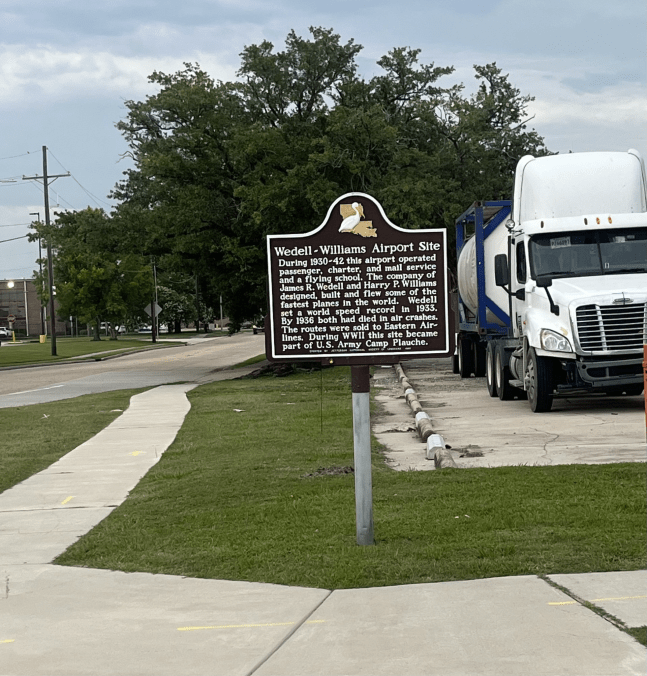
During 1930-42 this airport operated passenger, charter, and mail service and a flying school. The company of James R. Wedell and Harry P. Williams designed, built and flew some of the fastest planes in the world. Wedell set a world speed record in 1933. By 1936 both had died in air crashes. The routes were sold to Eastern Airlines. During WWII this site became part of U.S. Army Camp Plauche.
Erected by Jefferson Historical Society of Louisiana, 1990
Location
29° 56’ 54.852” N, 90° 10’ 51.102” W
Walmart Supercenter, 5110 Jefferson Hwy, New Orleans, LA 70123, United States