The Osceola mine was one of the most successful mining camps in Nevada. In 1872, a 12-mile gold-bearing quartz vein was discovered in the area. The rush didn’t really begin until 1877 when more gold was found in the canyon. But Osceola really didn’t take off until the 1880s when hydraulic mining was used. This type of mining uses water to remove sediment.
Osceola was not the most forgiving place to live. So, miners had to create two 18-mile-long pipelines to haul in water. Yet, the amount of water needed was not provided. Mining had actually started dropping off in the area until a massive gold nugget – valued at $6,000 – was found. This kept people motivated to continue mining until the 20th century.
Three fires hurt the town, but it was a massive fire during the 1940s that wiped out the town. By that point, the town had gone from a high population of 1,500 down to 100.
A few people still live in Osceola, but not many, and there are no services.
Historical Marker Inscription
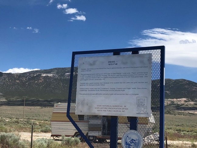
Osceola
1872-1940
Osceola, most famous of the White Pine County gold producers, was one of the longest-lived placer camps in Nevada.
The gold-bearing quartz belt found in 1872 was 12 miles long by 7 miles wide. Placer gold was found in 1877 in a deep ravine indenting the area. Miners first used the simple process of the common 49” rocker. Hydraulic monitors later were used to mine the gold from the 10’ to 200’ thick gravel beds. One gold nugget found was valued at $6,000.
Osceola was a good business town because of its location near the cattle and grain ranches and gardens in the Spring and Snake Valleys.
Famous district mines were the Cumberland, Osceola, Crescent and Eagle, Verde, Stem-Winder, Guilded Age, Grandfather Snide, Red Monster, and the Saturday Night.
The camp produced nearly $5 million, primarily in gold, with some silver, lead, and tungsten.
STATE HISTORICAL MARKER NO. 98
STATE HISTORIC PRESERVATION OFFICE
WHITE PINE PUBLIC MUSEUM, INC.
Location
39° 4’ 16.830” N, 114° 26’ 58.482” W
US-6, Ely, NV 89301, United States