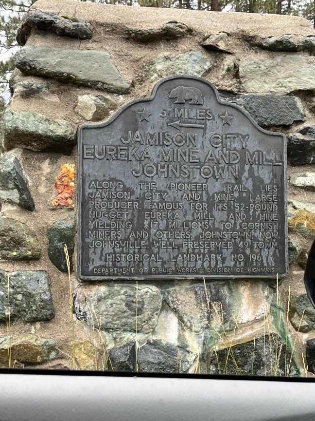
Gas Works, Yreka, California Historical Marker

Gas Works, Yreka, California Historical Marker

This historical marker commemorates the Yreka Gas Works. It was the company that first lighted the city streets on December 17, 1859. The marker sits in front of the Best Western Miner’s Inn.

No other information is available about this location.

Historical Marker Inscription

Site of the Yreka Gas Works which on Dec. 17, 1859 first lighted Yreka Streets. The gas was made by burning pine pitch.

Location

41° 43’ 59.148” N, 122° 38’ 6.228” W

300 N Main St, Yreka, CA  96097, United States

James Stuart Cain Historical Marker, Bodie, California

James Stuart Cain House Historical Marker, Bodie, California

Bodie ghost town is located in California off Highway 395. The reason that the town still stands today is largely due to James Stuart Cain. Cain moved to Bodie in 1879. He was only 25 but quickly made his fortune by investing in lumber, mining, freighting and banking. He brought lumber across Mono Lake, which helped build the town properties and mines.

Later, he would be the owner of the town bank as well as the Standard Mill. Cain and his family would own most of the town by the time he passed away in 1938. He and his family were dedicated to preserving the town, hiring security to guard it and caretakers to maintain the vacant buildings.

In 1962, the family gave the ghost town to the State of California. It is run by the California Department of Parks and Recreation. It is preserved in a state of “arrested decay” so that it looks exactly the same as it did during its heyday period. It was named a National Historic Landmark in 1961. The state legislature created the Bodie State Historic Park in 1962.

Historical Marker Inscription

Pioneer banker and mining man born in 1854 and moved to Carson City, Nevada, in 1875. Shortly thereafter he and Martha D. Wells of nearby Genoa were married and moved to Bodie where he engaged in lumber, freighting, banking, and mining operations. At one time he owned Mono County’s only bank. In 1938 Mr. Cain passed away at 84 years of age. Through his faith and efforts Bodie remains today.

Dedicated September 12, 1964.

Location

38° 12’ 47.892” N, 119° 0’ 42.430” W

Main St, Bridgeport, CA  93517, United States

Mount Lassen/The Noble Pass Historical Marker

Mount Lassen Historical Marker, Shingletown, California

This marker commemorates the early pioneers who crossed the peak of Mt. Lassen in 1852. Mt. Lassen sits at 10,451 feet. In May 1852, William H. Noble led emigrants through the Sierra via a wagon road. The pass linked the Humboldt-Nevada Road with Shasta and Northern California, and it was on this pass that the emigrants first looked at Sacramento Valley.

The previous year, Noble had seen the pass and recognized that it would work well for commercial use. He and a few other men convinced emigrants to start taking the pass in 1852. Because of his discovery and convincing pioneers to actually use the pass, it eventually became known as Noble Pass.

Historical Marker Inscription

Chaos Crags

Mt. Lassen

Mt. Lassen

10,451 Feet

This tablet marks the route of those early pioneers who, in 1852, first went over

The Noble Pass

Linking the Humboldt-Nevada Road with Shasta and Northern California, and their road is followed at this locality by

The Park Highway

Dedicated to the Pioneers of Northern California by Mr. & Mrs. B. F. Loomis

Sponsored by the Shasta Historical Society

MCMXXXI

Location

40° 33’ 29.058” N, 121° 31’ 54.528” W
Lassen Volcanic National Park Hwy, Shingletown, CA  96088, United States

The Emigrant Trail Historical Marker, Truckee, California

The Emigrant Trail Historical Marker, Truckee, California

This trail was the original wagon route that went over Donner Summit when emigrants moved west towards California. During the 1850s and 1860s, emigrants were heading to California, hoping to obtain land, gold or new opportunities. They often faced harsh conditions from the weather, terrain and attacks from Native Americans whose lands they were traversing or trying to take over.

The Emigrant Trail crossed many Midwestern states. Pioneers along this trail would eventually reach California, Utah, Washington or Oregon.

Currently, the trail is a recreational area for biking, hiking and other activities.

Historical Marker Inscription

The Emigrant Trail in the pioneer days of California came through the low pass to the north, facing this monument. The trail turned west at this point for a distance of twenty-six hundred feet where a tablet describes the route then followed.

Placed by Historic Landmarks Committee, Native Sons of the Golden West, September 14, 1929.

Location

39° 19’ 32.862” N, 120° 13’ 0.990” W
11769–11771 Donner Pass Rd, Truckee, CA  96161, United States