In the same place as the South Park historical marker on 285 at Kenosha Pass is another marker dedicated to Ralph Carr, a former governor of Colorado. Serving during World War II, Carr was the only Western governor to oppose the internment of Japanese Americans after the bombing of Pearl Harbor. He even gave speeches and wrote a letter published in the Pacific Citizen newspaper of the Japanese American Citizens’ League to encourage Japanese Americans to come to Colorado.
While only serving as governor for one term due to his resistance to the internment push, he did make Denver a popular postwar destination for Japanese Americans after they were released from internment camps. There was a large Japanese contingent in Colorado from the 1950s to the 1960s.
Carr’s support for Japanese Americans cost him the governorship, and he lost a Senate campaign in 1942. He tried running for Colorado governor again in 1950, but died right before the election at 62 years old.
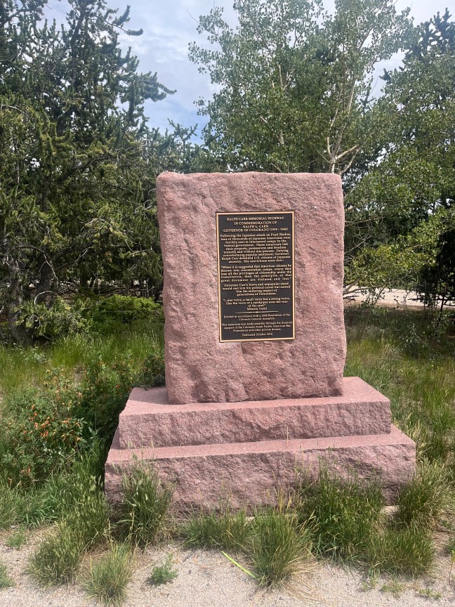
Historical Marker Inscription
Ralph Carr Memorial Highway in Commemoration of Ralph L. Carr Governor of Colorado (1939-1943)
Following the attacks of Pearl Harbor, tens of thousands of Japanese Americans were forcibly sent to internment camps by the federal government. These Americans lost their property, possessions and freedoms unjustly and without due process. Defying overwhelming popular sentiment, Governor Ralph Carr defended U.S. citizens of Japanese ancestry. His convictions were clear:
“When it is suggested that American citizens be thrown into concentration camps, where they lose all privileges of citizenship under the Constitution, then the principles of that great document are violated and lost.”
Governor Carr’s brave and unpopular stand would cost him his political career but earned him the enduring respect of generations of Coloradans.
“…one voice, a small voice but a strong voice, like the voice of a sandpiper over the roar of the surf.” – Minoru Yasui “
Erected in accordance with a 2008 Resolution of the Colorado General Assembly.
This memorial was made possible through the financial support of the Colorado Asian Pacific American Bar Foundation and other private donors.
Dedicated October 2010
Location: US-285, Lake George, CO 80827
Latitude: 39° 24′ 12.432″ N Longitude: 105° 45′ 16.152″ W