Gunnison Historical Marker, Utah

Gunnison Utah Historical Marker

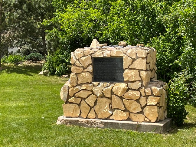
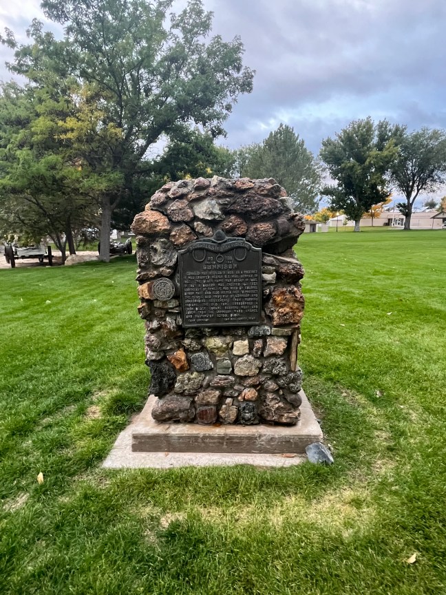
Named after Captain John W. Gunnison, an explorer responsible for finding a railroad route through the Rocky Mountains, the town was settled in the spring of 1859 by a group of Mormons. They were led by Bishop Jacob Hutchinson and directed to name the town by Brigham Young.

The original site of the town was located in a swampy area that was extremely muddy. When Brigham Young came to the area for a second visit in 1862, he recommended moving the town to its present location. The new location didn’t have a water source so the first task was to dig a ditch from the river to the town.

The early settlers came into conflict with the local Native Americans during the Black Hawk War. Some settlers died during the conflict, but the majority stayed and thrived.

Agricultural activities have been the main staple of the area since its inception. Sugar beets, which can be turned into sugar, were a main export. By 1900, due to the construction of the railroad, the population had doubled. Gunnison officially became a town in 1893.

In present times, cattle, dairy, small grains and alfalfa provide the main sources of income for the valley.

Historical Marker Inscription

Gunnison was settled in 1859. As a precinct it was granted weekly U.S. Mail service in 1862. The Black Hawk War began in 1865. In 1867 a bastion was erected 362 feet southeast of here. It was used by Colonel Byron Pace and 1500 militia men to protect the people and property of Gunnison and surrounding settlements from warring Indians. The old fort surrounded a four block square running west and south from the Gunnison Ward Chapel and Washington School block.

San Pete County, Utah

Location

39° 9’ 32.170” N, 111° 49’ 6.642” W
Gunnison City Park, 285 N Main St, Gunnison, UT  84634, United States

Settlement of Hatch Historical Marker, Hatch, Utah

Settlement of Hatch Historical Marker, Hatch, Utah

Known initially as Hatch or Hatchtown, the town was created Meltiar Hatch and his two wives, Mary Ann and Permelia, and their children. It was an order by the Church of Latter-Day Saints leaders to settle the Dixie Mission. The three thought they were in Utah, but redrawn boundary lines had put the settlement in Nevada.

After discussions with Brigham Young,  everyone decided to move back to Utah. The first move was to Panguitch in South Utah. Later, the family moved 20 miles to the south where Mammoth Creek connects with the Sevier River. Other settlers also began moving into the area. The Hatch home was the central location of both LDS worship and school sessions. This is why the town was named Hatchtown.

In the early 1900s, The Upper Sevier Reservoir Company decided to build a dam despite the fears of the community. In 1903, the dam broke. It was rebuilt, and then the dam broke again in 1914. During the second dam break, many homes were destroyed, and people were left homeless. This was one of the reasons that the town was moved one and a half miles south of the original location. The town of Hatch was incorporated on January 3, 1934.

Historical Marker Inscription

In 1872 Meltiar Hatch settled at the head of the Sevier River, near the junction of Mammoth and Asay Creeks. He engaged in stock raising and operated a water-power sawmill. Soon other settlers came. Land was surveyed and irrigation ditches dug. Lime was burned by Neils P. Clove. First school was in the Hatch home, Abram Workman teacher. 1888 the Asay post office was transferred to Hatch, Neils Ivor Clove, Postmaster. In 1892 the Church of Jesus Christ of Latter-day Saints organized Mammoth Ward, Aaron Asay, Bishop. 1899 the Ward name was changed to Hatch. 1901 to 1904, the town was moved to the present site under the leadership of Bishop Rosmus Lynn.

Erected by The Daughters of Utah Pioneers in 1964, No. 292

Location

37° 38’ 59.280” N, 112° 26’ 4.482” W
2–24 W Center St, Hatch, UT 84735, United States

The Berry Family Historical Marker, Glendale, UT

The Berry Family Historical Glendale, UT

Originally called Berryville, Utah, the site had been settled in 1862. The first group was led by John and William Berry. Later the area came to be known as Glendale. While initially only a simple water power mill was developed on the site, due to Native American incursions, a stockade was built in 1865.

By 1866, all settlements throughout Kane County, including Berryville, were vacated due to conflicts with the Native Americans. Robert Berry, Isabella Berry, wife of Robert Berry, and Joseph Berry were killed by Native Americans on Short Creek.

The area was resettled in 1871 by settlers from the Muddy Mission in Nevada.

Historical Marker Inscription

Four early Church pioneers, sons of Jesse Woods and Amelia Shanks Berry, were the founders of Berryville, now Glendale, Utah. Joseph S. and Robert M. and his wife Isabelle Hale Berry, were killed by Indians April 2, 1856. They are buried in Grafton, near Rockville. A mob shot and killed William Shanks Berry while on a mission in Tennessee in 1884. John William, while carrying mail for Brigham Young, was shot by an Indian and carried the bullet until his death.

A large and faithful posterity live to honor them.

Location

37° 19’ 6.000” N, 112° 35’ 51.558” W
25 N Main St, Glendale, UT  84729, United States

Replica of the Bluff Meeting House, Bluff, Utah

Replica of the Bluff Meeting House Bluff Utah

The Bluff meetinghouse was part of the Bluff Fort. Initially, residents would meet under an old cottonwood tree near the San Juan River. When a swing was attached to the tree, it become known as the “Swing Tree”. Later, the people realized that they needed a better place to meet so the meetinghouse was built at the end of 1880.

At first, it was a double-length cabin. It later was expanded with a new section to make it larger. Besides a meetinghouse, it was also used as a schoolhouse, community center and courthouse.

The Bluff Fort was built along a wagon road established by Mormon pioneers. It was part of the “Hole-in-the-Rock Expedition” which began in 1879. The goal of the expedition had been to create a mission at Montezuma along the San Juan River. The pioneers decided to use a route known as the “Escalante shortcut” believing that the journey would take six weeks. In reality, it took 6 months and 260 miles on the Hole-in-the-Rock Trail.

Since the trail was not designed for wagons, it had to be chiseled and blasted open in the Hole-in-the-Rock sandstone cliffs. After traveling for months, the pioneers decided to not pursue the last 20 miles to the intended location. Instead, they settled in the area that would become Bluff City in 1880.

Replica of the Bluff Meeting House Bluff Utah

Historical Marker Inscription

Sketched by Remington Lange 1893

Bluff’s log meetinghouse was the center of all public gatherings for the small community on the remote San Juan frontier. The meetinghouse, which was part of the north wall of the Bluff Fort, served as chapel, courthouse, ballroom, concert hall and schoolhouse. It was a place where pioneers were entertained with dances, dramatizations and musical performances. It was also a place of worship and learning, and on occasion, it sheltered families whose mud roofs failed to keep the rain out or whose cabins were flooded by the river. The meetinghouse was built in the latter part of 1880. “It offered a handy place for friends to meet, and for strolling lovers to rest in the evening. …not just a church, but simply a meetinghouse, vested with all essentials for solemn worship, but not too good nor too nice for any lawful service to the busy pioneers.” On Christmas, “…children thronged the old log school house during the day, and the place became the scene of many a merry party in long winter evenings.” —Albert R. Lyman

This site is being developed and maintained by the Hole-in-the-Rock Foundation

Location

37° 17’ 3.582” N, 109° 33’ 10.968” W

550 Black Locust Ave, Bluff, UT  84511, United States

Nielsen Grist Mill Historical Marker, Utah

Nielsen Grist Mill, Teasdale, Utah Historical Marker

Located in Wayne County, Utah, the 120-year-old Nielsen Grist Mill is still standing. It is the only mill left in the state that still has the original water-powered equipment.

Built by Danish miller, Hans Peter Nielsen, in the late 1800s, it was a two and half story mill that operated until 1935. It was destroyed by fire in the late 1800s and rebuilt, and then it was remodeled in 1910.

The mill is currently being restored, and it is located on private property on Highway 24 west of Torrey, heading towards Capitol Reef National Park. It was listed on the National Register of Historic Places in 1975.

Historical Marker Inscription

The Nielsen Grist Mill is located at the foot of Thousand Lake Mountain on the edge of scenic country referred to by ancient Indians as “The Land of Sleeping Rainbow.” Constructed around 1893 for Hans Peter Nielsen by his son-in-law, Niels Hansen, the mill was known as the Thurber Rolling Mills. Water for powering the mill was channeled from the Fremont River and dropped 22 feet through a-wooden pipe to the turbine that ran the mill.

The mill still has a double stand of Wolf Rolls and two double stands of McNalley Rolls with scalpers under each that are spouted to the various elevator legs. Sixteen elevators with five reels for flour milling are found in the mill. The Barnard and Leas dust collector and turbine with belting still have pulleys made of native wood, ready for use. Old models of Howe Scales, one for weighing wheat and one for weighing flour sacks, still exist. All equipment is in good shape, including the cash register. The mill produced flour, germade, shorts, and bran, each coming from individual spouts.

Farmers would receive one sack of flour for each three sacks of wheat. All 48-pound bags of flour were sewn by hand. The space between the ears was sewn with a long, sharp needle with a built-in thread cutter.

The mill made flour for the surrounding area for 40 years. Improved roads, constructed in the 1930s, spelled the beginning of the end for the Thurber Rolling Mills. Since Wayne County could not grow hard wheat, which made the best bread, it became just as easy to truck in flour as hard wheat.

1999 No. 522 Camp Thurber

Location

SR-24, Teasdale, Utah 84773, United States

38° 18′ 25.350″ N, 111° 30′ 28.980″ W

Major Powell, Colorado River Explorer

John Wesley Powell was a geologist and explorer of the American West. He had also been a soldier for the Union Army during the American Civil War. Powell, however, is most well-known for his series of expeditions throughout the Rocky Mountains and the Green and Colorado Rivers.

In 1869, Powell and nine other members of his team set out into the West to explore both the Colorado River and the Grand Canyon. They had four boats and enough food for 10 months for their trip through Utah. Only six crew members made it all the way through the expedition. One quit early in the journey and three left right before the crew reached the mouth of Virgin River on August 30, 1869, where the journey ended.

The three men who quit headed out at Separation Canyon and were never seen again. There has been speculation for years as to what happened to these three. Because they were never found, many of Powell’s journals were lost because they had been sent out with them. We recently heard a story that a journal had been discovered by a young Mormon girl who wrote about three men entering their village. The elders took these three out of village, and nothing more was written.

The Marker

The Powell historical marker is located 1084 East Main Street in Elgin, UT – right in front of the Motel 6. Here is what is engaged on it:

The first organized attempt to conquer the swirling rapids and precipitous walled canyons of the Green and Colorado Rivers was made by Major John Wesley Powell, Civil War hero and explorer. Warned by Indians and mountaineers they would never return alive, Powell and 9 companions started from Green River Station, Wyoming Territory, on May 24, 1869, with 4 boats, instruments for making scientific observations, and provisions to last 10 months. For 97 days Powell and his men battled the elements, enduring tremendous deprivation and hardship.

One man (Frank Goodman) left the company early in the journey, and 3 others (William Dunn, O.G. and Seneca Howland) later killed by Shivwits Indians, deserted near Grand Canyon, Arizona. On August 29, 1869, the 6 remaining men arrived at the junction of the Rio Virgin in southern Nevada, having navigated and charted over 900 miles of the river.

In May, 1871, 2 years after his first river voyage, J.W. Powell again led an exploring party of 11 men in 3 boats down the Green and Colorado Rivers. Well into 1873 members of Powell’s party continued extensive and significant exploration and surveys of the region bordering the rivers traversed. The Powell Surveys are some of the most significant explorations achieved anywhere in the world.

NW 1/4, NW 1/4, NE 1/4, Sec. 15, TWP 21S, R 15E