The Emigrant Trail Historical Marker, Truckee, California

The Emigrant Trail Historical Marker, Truckee, California

This trail was the original wagon route that went over Donner Summit when emigrants moved west towards California. During the 1850s and 1860s, emigrants were heading to California, hoping to obtain land, gold or new opportunities. They often faced harsh conditions from the weather, terrain and attacks from Native Americans whose lands they were traversing or trying to take over.

The Emigrant Trail crossed many Midwestern states. Pioneers along this trail would eventually reach California, Utah, Washington or Oregon.

Currently, the trail is a recreational area for biking, hiking and other activities.

Historical Marker Inscription

The Emigrant Trail in the pioneer days of California came through the low pass to the north, facing this monument. The trail turned west at this point for a distance of twenty-six hundred feet where a tablet describes the route then followed.

Placed by Historic Landmarks Committee, Native Sons of the Golden West, September 14, 1929.

Location

39° 19’ 32.862” N, 120° 13’ 0.990” W
11769–11771 Donner Pass Rd, Truckee, CA  96161, United States

Settlement of Hatch Historical Marker, Hatch, Utah

Settlement of Hatch Historical Marker, Hatch, Utah

Known initially as Hatch or Hatchtown, the town was created Meltiar Hatch and his two wives, Mary Ann and Permelia, and their children. It was an order by the Church of Latter-Day Saints leaders to settle the Dixie Mission. The three thought they were in Utah, but redrawn boundary lines had put the settlement in Nevada.

After discussions with Brigham Young,  everyone decided to move back to Utah. The first move was to Panguitch in South Utah. Later, the family moved 20 miles to the south where Mammoth Creek connects with the Sevier River. Other settlers also began moving into the area. The Hatch home was the central location of both LDS worship and school sessions. This is why the town was named Hatchtown.

In the early 1900s, The Upper Sevier Reservoir Company decided to build a dam despite the fears of the community. In 1903, the dam broke. It was rebuilt, and then the dam broke again in 1914. During the second dam break, many homes were destroyed, and people were left homeless. This was one of the reasons that the town was moved one and a half miles south of the original location. The town of Hatch was incorporated on January 3, 1934.

Historical Marker Inscription

In 1872 Meltiar Hatch settled at the head of the Sevier River, near the junction of Mammoth and Asay Creeks. He engaged in stock raising and operated a water-power sawmill. Soon other settlers came. Land was surveyed and irrigation ditches dug. Lime was burned by Neils P. Clove. First school was in the Hatch home, Abram Workman teacher. 1888 the Asay post office was transferred to Hatch, Neils Ivor Clove, Postmaster. In 1892 the Church of Jesus Christ of Latter-day Saints organized Mammoth Ward, Aaron Asay, Bishop. 1899 the Ward name was changed to Hatch. 1901 to 1904, the town was moved to the present site under the leadership of Bishop Rosmus Lynn.

Erected by The Daughters of Utah Pioneers in 1964, No. 292

Location

37° 38’ 59.280” N, 112° 26’ 4.482” W
2–24 W Center St, Hatch, UT 84735, United States

The Oregon Trail – Cold Spring Camping

Cold Spring Camping Ground Historical Marker, Guernsey, WY

The Cold Springs campground was a major camping spot along the Oregon-California-Mormon Trail. The marker indicates not only the spot where emigrants stopped. It also indicates the rifle pits that soldiers used to protect the area.

Historical Marker Inscription

The Oregon Trail

1841

Cold Spring Camping Ground. Rigle Pits On Brow Of Hill 500 Feet North

Erected by the Historical Landmark Commission of Wyoming

1943

Location

42° 16’ 1.470” N, 104° 47’ 25.680” W

1251 US-26, Guernsey, WY  82214, United States

Nielsen Grist Mill Historical Marker, Utah

Nielsen Grist Mill, Teasdale, Utah Historical Marker

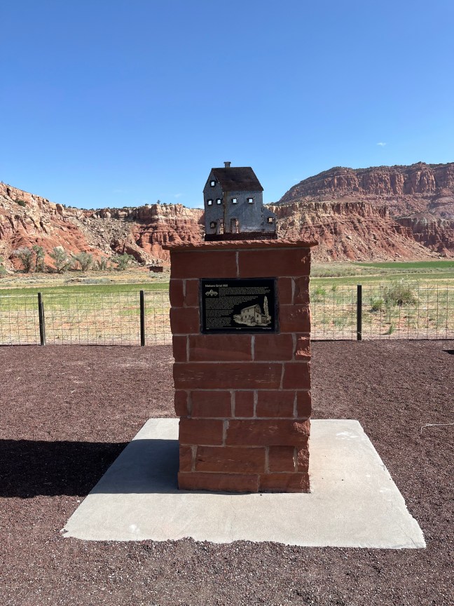
Located in Wayne County, Utah, the 120-year-old Nielsen Grist Mill is still standing. It is the only mill left in the state that still has the original water-powered equipment.

Built by Danish miller, Hans Peter Nielsen, in the late 1800s, it was a two and half story mill that operated until 1935. It was destroyed by fire in the late 1800s and rebuilt, and then it was remodeled in 1910.

The mill is currently being restored, and it is located on private property on Highway 24 west of Torrey, heading towards Capitol Reef National Park. It was listed on the National Register of Historic Places in 1975.

Historical Marker Inscription

The Nielsen Grist Mill is located at the foot of Thousand Lake Mountain on the edge of scenic country referred to by ancient Indians as “The Land of Sleeping Rainbow.” Constructed around 1893 for Hans Peter Nielsen by his son-in-law, Niels Hansen, the mill was known as the Thurber Rolling Mills. Water for powering the mill was channeled from the Fremont River and dropped 22 feet through a-wooden pipe to the turbine that ran the mill.

The mill still has a double stand of Wolf Rolls and two double stands of McNalley Rolls with scalpers under each that are spouted to the various elevator legs. Sixteen elevators with five reels for flour milling are found in the mill. The Barnard and Leas dust collector and turbine with belting still have pulleys made of native wood, ready for use. Old models of Howe Scales, one for weighing wheat and one for weighing flour sacks, still exist. All equipment is in good shape, including the cash register. The mill produced flour, germade, shorts, and bran, each coming from individual spouts.

Farmers would receive one sack of flour for each three sacks of wheat. All 48-pound bags of flour were sewn by hand. The space between the ears was sewn with a long, sharp needle with a built-in thread cutter.

The mill made flour for the surrounding area for 40 years. Improved roads, constructed in the 1930s, spelled the beginning of the end for the Thurber Rolling Mills. Since Wayne County could not grow hard wheat, which made the best bread, it became just as easy to truck in flour as hard wheat.

1999 No. 522 Camp Thurber

Location

SR-24, Teasdale, Utah 84773, United States

38° 18′ 25.350″ N, 111° 30′ 28.980″ W