
Located near the Haystack Mountains and the North Platte River, Guernsey, Wyoming, was originally known as the “emigrant wash tub” since it was the area where the pioneers typically washed their clothes, took baths and watered whatever livestock they had with them. Guernsey was located right on the Oregon Trail. You can still see the ruts from the wagons in the area, and the carved names of the pioneers who traveled along the route.
The area is named after Charles A. Guernsey, a New Yorker who moved to the area in 1880. The town was officially incorporated in 1902. By this year, the Chicago, Burlington and Quincy Railroad had made it as far as Guernsey.
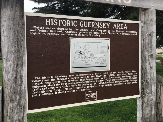
Historical Marker Inscription
Platted and established by the Lincoln Land Company of the Chicago, Burlington and Quincy Railroad, Guernsey garners its name from Charles A. Guernsey, noted legislator, rancher, and investor in early Wyoming.
The historic Guernsey area encompasses a key stretch of the North Platte River Valley from the Nebraska border west to the Hartville Uplift. The river forms an historic transportation corridor that began with the Native Americans, continued with emigrants along the Oregon/California/Mormon Pioneer/Pony Express National Historic Trails and continues today with US Highway 26, which has been designated the Oregon Trail Historic Byway. Major irrigation projects, large mining operations, a state park, and a military training center are nearby.
Location
60-98 East Whalen Street, Guernsey, WY 82215, USA
42°16’11.298″ N, 104° 44′ 24.870″ W

