Casa de Armijo Historical Markers, Albuquerque, New Mexico

Old Town Cafe Casa de Armijo Historical Marker

Casa Armijo was built by El Colorado Don Juan Nepomuceno Armijo in 1706.  It was later sold to Ambrosio Armijo. One of the first homes in Old Town, the large adobe hacienda sits in the plaza in Old Town Albuquerque.

Throughout its years, the home has been used for a variety of purposes. During the earliest parts of the settlement of the area, it was used as a fort. Over the years, the location was under different flags: Spanish, Mexican, Confederate, Union and, finally, the United States.

Later, the family turned it into a trading post. In 1931, the location was turned into La Placita Dining Rooms, a restaurant with a tree growing in its dining room. The building was recently sold and turned into Old Town Cafe. The current owner, Michelle La Meres, is a descendant of the Armijo family.

Historical Marker Inscription

(Located on front of the building)

Old Town Cafe

Casa de Armijo

Built in 1706 and occupied for many generations by the Armijo family who were prominent in local history. This hacienda was gay with social life.

During the turmoil of the early settlement the Mexican, Spanish and American Civil War occupation it was used as a fort and a refuge.

Later, still occupied by the Armijo family, portions were used as an early trading post.

In 1930 it was restored from a ruin to its present condition and remodeled in conformity with its old character.

(Located on side of the building)

Casa de Armijo Historical Marker Old Town Albuquerque
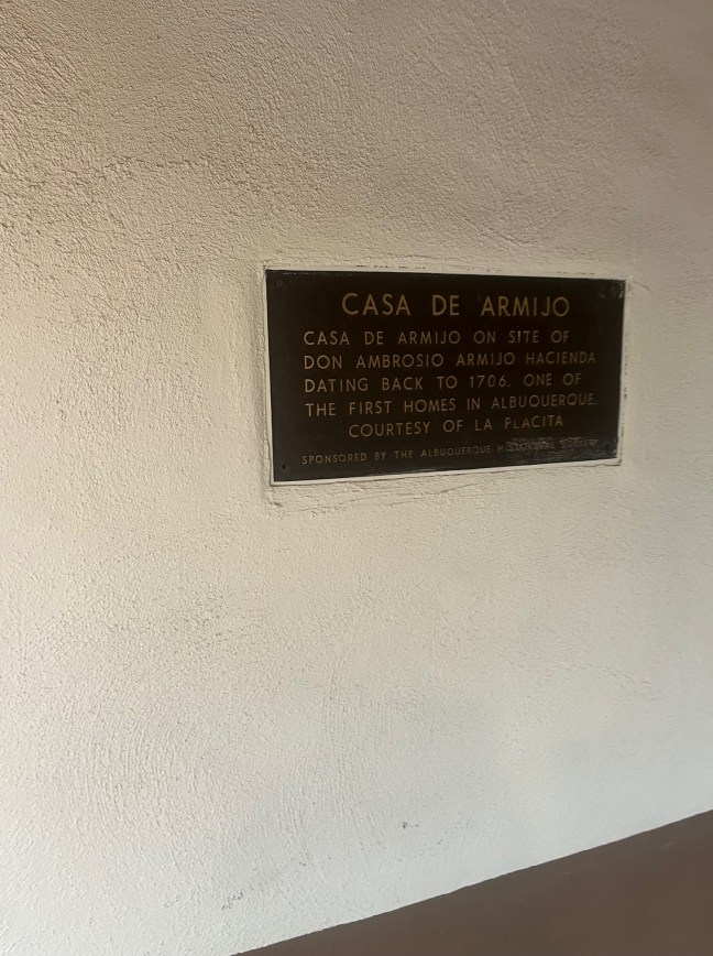
Casa de Armijo on site of Don Ambrosio Armijo hacienda dating back to 1706. One of the first homes in Albuquerque.

Courtesy of La Placita

Sponsored by The Albuquerque Historical Society.

Location

35° 5’ 44.920” N, 106° 40’ 9.822” W
204 San Felipe St NW, Albuquerque, NM  87104, United States

Beclabito Dome Historical Marker

Beclabito Dome Historical Marker

Located in the Four Corners area on First Nations Diné (Navajo) Nation Land, the geological dome was created due to volcanic activity. Deep in the earth, extremely hot temperatures liquified the rocks. When they reached the surface, they cooled and hardened again. The hot magma beneath these re-hardened rocks kept pushing to the surface. This created this unique dome.

Historical Marker Inscription

Colorful red rocks of Entrada Sandstone are domed up by deep seated igneous intrusions to be exposed by erosion. The same igneous activity created the Carrizo Mountains to the west. Uranium deposits in the Morrison Formation just above the Entrada created New Mexico’s first uranium boom in the East Carrizo south of here in the 1950’s. Elevation 5,600 feet.

Location

36° 49’ 51.912” N, 109° 0’ 53.090” W498 US-64, Shiprock, NM  87420, United States

Jack M. Campbell Historical Marker, Taos, NM

Jack M Campbell Historical Marker

Governor Jack M. Campbell was a Democratic governor of New Mexico from 1963 to 1966. He was elected as governor on November 6, 1962, and again in 1964. He was also part of the New Mexico House of Representatives from 1955 to 1962, serving the last two years as speaker.

This stretch of U.S. 64 was named in honor of him by the members of the New Mexico State Highway Commission on September 23, 1965.

Historical Marker Inscription

Taos to Tierra Amarilla

This road passes through some of the most spectacular scenery in the American Southwest. It is a key section of the east – west highway which brings visitors to this region from throughout the United States. Since this route became a reality through the leadership and perseverance of Governor Jack M. Campbell (1963-1966), the members of the New Mexico State Highway Commission voted unanimously on September 23, 1965 to name this portion of U.S. 64 in his honor.

Location

El Prado, New Mexico 87571, United States

36° 30′ 38.400″ N, 105° 39′ 24.642 W

Fort Union National Monument 1851-1891

Fort Union National Monument Historical Marker, NM

Fort Union was the largest military fort in the 19th century in the American Southwest. It was established in 1851 to protect the Santa Fe Trail and lasted for 40 years. The fort was actually three different forts with the third and last fort being the largest of the three.

Fort Union acted as a military supply depot, military garrison and territorial arsenal for the entire region.

Besides the remains of the fort, visitors can also see Santa Fe Trail ruts.

Historical Marker Inscription

Once the largest post in the Southwest, Fort Union was established to control the Jicarilla Apaches and Utes, to protect the Santa Fe Trail, and to serve as a supply depot for other New Mexico forts. The arrival of the railroad and the pacification of the region led to its abandonment in 1891.

Location

35° 44′ N, 105° 2.717′ W.

Traveling North on Interstate 25, Mile Marker 360, near Las Vegas, New Mexico

Pueblo of San Ildefonso, Los Alamos, NM

Pueblo de San Ildefonso Church

The history of Pueblo de San Ildefonso dates back to the 1300s when the original inhabitants moved from the Bandelier area to this location after a prolonged drought.  The Pueblo is close to the Rio Grande. These Ancient Puebloans had originally come from the settlement at Mesa Verde, Colorado.

In the 1500s, the Puebloans came in contact with the Spanish. In 1591, Casper Castaño visited the Pueblo. Then, in 1595, Antonio Gutierrez de Umana, and Francisco Leyba de Bonilla headed an unauthorized expedition into New Mexico. They made San Ildefonso their main headquarters.

In 1598, Juan de Oñate came to the area and officially gave the Pueblo its name. Around this time, the village was moved to its present location. Later in 1610, Fray Andrés Bautista created the first permanent mission here.

But the Spanish brought troubles to the people. They required that the Pueblo communities pay tribute to them as well as convert to Catholicism. The Pueblo Revolt of 1680 resulted in the Spanish being expelled from the region for a while, and the San Ildefonso people were a major part of that uprising.

The people resisted the Spanish for several more years after they came back to the area. It wasn’t until 1694 that the Spanish were able to remove the Tewa and Tano people from the mesa. Then, a drought in 1695 that weakened the colonists encouraged the Pueblos to rebel again in 1696. But the mission was reestablished, and a church was built in the village in the 1700s.

In 1821, the area was ruled by Mexico. In 1848, after the Treaty of Guadalupe Hidalgo, it became part of the United States. After Congress created the reservation system in 1858, a grant of over 17,000 acres of land was given to the village in 1864. It is still a federally recognized tribe.

The Pueblo is today comprised of 60,000 acres and about 750 people live there. It is made up of traditional kivas, a central plaza and a 1960s replica of a 1700s church.

Historical Marker Inscription

Pueblo de San Ildefonso Historical Marker

In the 1500s, migrants from the Pajarito Plateau joined their Tewa-speaking relatives at San Ildefonso. The pueblo is famous as the home of the late Maria Martinez and other makers of polished black pottery. The modern church, a replica of that of 1711, was finished in 1968.

Location

Off State Road 502 along the Rio Grande Valley, East of Los Alamos

N 35.89197, W 106.11836

First Wagons Used on Santa Fe Trail

The Santa Fe Trail was a two-way commercial highway that connected Missouri to Santa Fe. Used between 1821 and 1889, it was frequented by both American and Mexican traders. It was also a path that the U.S. Army used to invade Mexico during the Mexican-American War.

Besides commerce, the Santa Fe Trail was also used during the Gold Rush by people heading to gold fields in both California and Colorado as well as by missionaries, emigrants and more.

The expansion of the railroad into Santa Fe in February 1880 brought an end to the trail.

Historical Marker Inscription

“First Wagons Used on Santa-Fe Trail Crossed Here in 1822.”

Accompanying sign:

“Stretching 900 miles from Franklin, Missouri, to Santa Fe, New Mexico, the Santa Fe Trail as one of the most important North America trade routes of the nineteenth century. Begun in 1821, it was used for 60 years until the arrival of the railroad. It was a hardy traveler who attempted the journey. Wagon trains up to 500 wagons long traversed the trail through blizzards, stampedes, dust storms, fires, disease, and Indian attacks. And often, they lacked for water.

Here, near two landmarks of the trail, Round Mound and Rabbit Ears, wagon trains camped for the night. William Becknell, the trader who inaugurated the Santa Fe Trail in 1821, came this way on his return trip east while forging the smoother Cimarron Route across the plains.

Two-way Street

Unlike the great emigrant trails to the north, the Santa Fe Trail ran both ways, with traders from Mexico, or returning U.S. traders, carrying Mexican silver, gold, mules, buffalo and beaver pelts to waiting markets in Missouri.”

Location: US-87 West, Clayton, New Mexico
Latitude: 36

Location: US-87 West, Clayton, New Mexico
Latitude: 36 degrees 33′ 59.520″ N
Longitude: 103 degrees 34′ 1.152″ W

Capulin Volcano

Driving down Highway 325 in New Mexico near Raton, you can’t miss the sign for Capulin Volcano National Monument. This national monument is an extinct cinder cone volcano that is part of the 8,000 square mile Raton-Clayton Volcanic Field. Designed to provide visitors with a look at the geology of Northwestern New Mexico, you can also view four states from the rim of the volcano.

The elevation of the volcano is 8,182 feet high and 400 feet deep, and it is approximately 60,000 years old. The name is derived from a type of choke cherry, Prunus virginiana. The area became a national monument on August 9, 1916.

Historical Marker Inscription

“An outstanding example of an extinct volcanic cinder cone, Capulin Volcano was formed as early as 10,000 years ago. In cinder cones, lava pours from cracks in the base rather than over the top. Capulin itself was the escape hatch for cases that blew lava fragments into the air where they solidified and landed red hot on the cone.”

Location: 46 Volcano, Capulin, NM 88414
36.7811 degrees North, 103.9695 degrees West

Site of Santa Fe’s First Chapel

Santa Fe, New Mexico Historical Marker: First Chapel

Santa Fe is a mecca of history, so there are plenty of historical markers in the area. On the southeast corner of the Place of the Governors lies the historical marker for Santa Fe’s first chapel.

According to the marker, the chapel was “Also used as two story defensive tower for Palace of the Governors during the 1600’s. Gen. Don Diego de Vargas was probably buried beneath the floor of this chapel in 1704”. The chapel was demolished in 1774.

Don Diego de Vargas

Diego de Vargas Zapata y Luján Ponce de León y Contreras, better known as Don Diego de Vargas, was a Spanish Governor of the territory of Santa Fe from most of the 1690s until 1704. He was in charge of the reconquest of the New Mexico territory after the Pueblo Revolt in 1692.

The Pueblo Revolt started in August 1680, and involved Pueblo people from different pueblos. While traditional extremely peaceful people, the Pueblo people were treated cruelly by the Spanish rulers. They overthrew Spanish rule in New Mexico and held the area for more than 12 years.

Location: N 35° 41.261 W 105° 56.266