
The first gas well discovered in the Panhandle of Texas was found by Dr. Charles Newton Gould and his team. Gould was a geologist born near Lower Salem, Ohio, on July 22, 1868. Having received a masters degree in geology in 1900, he was tapped as a territorial geologist and geology instructor by the University of Oklahoma. While during the fall he taught classes, over the summer months, he worked in the Indian Territory (areas where the government relocated Native American populations) on federal geological surveys.
During the summer of 1903, Gould was commissioned by the Hydrographic Branch of the United States Geological Survey to survey the geology and try to find underground water sources west of the Indian Territory and east of the Rocky Mountains. Over the course of three seasons during 1903 through 1905, Gould and his compatriots mapped the geological features of the Texas Panhandle.
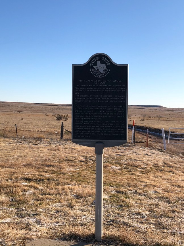
Historical Marker Text
The discovery well in the vast Panhandle-Hugoton Gas Field, largest known gas field in the world, is located one mile east of this point on the east slope of John Ray Butte.
The geological structure was discovered by Dr. Charles N. Gould in 1905 while in the employ of the United States Geological Survey, and the well was located by him in 1917.
This well, the Hapgood, Masterson No. 1, was started December 1, 1917, and completed at a cost of $70,000 as a gas well December 7, 1918, at a depth of 2605 feet. It produced about 5,000,000 cubic feet of gas per day. This discovery initiated the development of this great gas field and of the Panhandle oil fields.
The gas field now extends 275 miles from the Texas Panhandle north into Kansas, with a width in places of more than 90 miles. Pipelines from this field transmit gas to Denver, Kansas City, St. Louis, Chicago, Detroit, and to most of the cities and towns of the mid-west. Lines also carry gas to Los Angeles and to other cities and towns on the west coast. (1965)
Location: 35.573383, -101.949463
Located 30 miles north of Amarillo off US 287

