Capon Lake Whipple Truss Bridge, West Virginia

Capon Lake Whipple Truss Bridge, WV

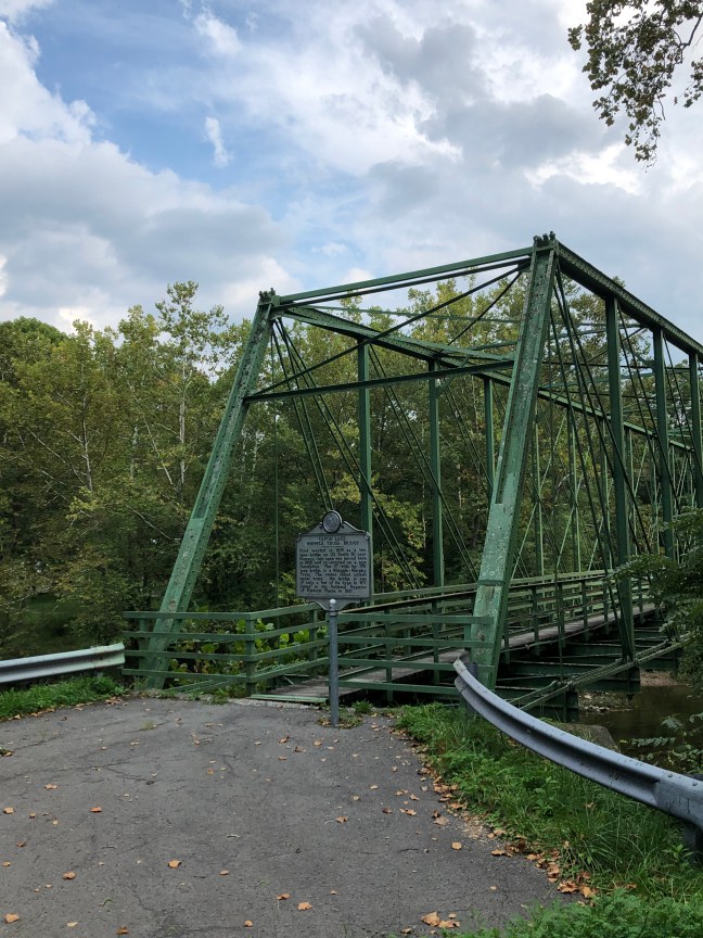
The Capon Lake Whipple Truss Bridge was built in 1874 to replace a wooden-covered bridge. The former bridge had been destroyed during the Civil War by Confederate soldiers.

The bridge was built by T.B. White and Sons using the Whipple truss, which was created by Squire Whipple and patented in 1847.  It was a stronger version of the Pratt truss and was known as the “Double-intersection Pratt” due to the fact that the diagonal tension members crossed two panels as opposed to the one used in the Pratt design. It typically had a trapezoidal look. Because it was stronger and firmer than the original design, it was embraced by the railroads.

The Capon Lake Whipple Truss Bridge is West Virginia’s oldest extant metal truss. It stopped being used in 1991 after the construction of a new bridge. It was added to the National Register of Historic Places in 2011.

Historical Marker Inscription

First erected in 1874 as a two span bridge on US Route 50 near Romney, one span was moved here in 1938 and re-erected on a new foundation. the 17′ wide by 176′ long bridge is a Whipple-Murphy Truss. The state’s oldest extant metal truss, the bridge is one of only a few of its type in WV. Listed in the National Register of Historic Places in 2011.

Location

10001-10099 Carpers Pike, Yellow Spring, West Virginia 26865 United States

39° 9′ 32.150″ N, 78° 32′ 5.820″ W

Mosby’s Rock Historical Marker, Herndon, Virginia

Mosby's Rock, Herndon, VA

Known as the “Gray Ghost”, John S. Mosby was part of the Confederate Army’s 43rd Virginia Cavalry Battalion during the American Civil War. Known as a rabble-rouser, he was head of a partisan ranger unit that was known by several names, including Mosby’s Raiders, Mosby’s Men and Mosby’s Rangers.

The unit was renown for its raids on Union targets and ability to evade capture. During the course of the war, Mosby’s Raiders were able to disrupt Union communications, supply lines and outposts.

A spy working for Mosby, Laura Ratcliffe, in 1863 recommended using a large rock (located in Herndon, VA) as a meeting place where the soldiers could meet after doing raids. Ratcliffe also hid money and messages under the rock, the latter which Mosby credited with helping him escape from capture by Union soldiers.

While Mosby did daring deeds during the Civil War, he was held in contempt by many of his fellow Virginians after the war. He admitted that the Confederacy had lost the war while many others still believed in the “Lost Cause” myth. This myth revolves around the belief that the South was in the right and heroic, and it tries to paint the antebellum South in the best light.

The rock is still there, but it borders a subdivision. Since 2020, the marker on the rock has been missing. It was said to read as follows: “Mosby’s Rangers (43d Bn., Va. Cav.) used this rock as a rendezvous point and met here to divide the spoils after raids. The renowned Southern spy and scout Laura Ratcliffe, who lived nearby, showed this rock to Col. (then Captain) John S. Mosby, CSA, in 1863, and suggested he use it as a meeting place”.

Historical Marker Inscription

Mosby's Rock Historical Marker

This large boulder, located just south of here, served as an important landmark during the Civil War, when Col. John S. Mosby’s Partisan Rangers (43rd Battalion, Virginia Cavalry) assembled there to raid Union outposts, communications, and supply lines. Laura Ratcliffe, a young woman who lived nearby and spied for Mosby, concealed money and messages for him under the rock. Mosby credited her with saving him from certain capture by Federal cavalry on one occasion. She also was a friend of Maj. Gen.  J.E.B. Stuart.

Location

13570 Big Boulder Road, Herndon, Virginia, 20171 United States

38° 56′ 47.340″ N, 77° 24′ 57.000″ W

Boggsdale, Long Beach, Mississippi

Boggsdale, MS Historical Marker

Boggsdale is the area of the family home of Thomas Hale Boggs, the late U.S. Congressman from Louisiana who died in a plane crash in Alaska on December 29, 1972.

Seven acres of beachfront property was purchased by Georgian artist and writer, Robert Boggs, and wife, Eliza Jane, in 1875. The area would eventually become Long Beach. The house they built was named Breezydale. According to legend, Native Americans warned the family not to build so close to the Sound.

The property was inherited by the couple’s son, William, and wife, Claire Hale. The other son, Archibald, and his wife, Bessie, were given adjacent land. They built a home by the name of Driftwood, which was named after lumber that had washed ashore.

A major hurricane in 1947 destroyed both homes and killed Bessie. Breezydale was rebuilt 600 feet back from the water and was named Will-Stan, but that property was also destroyed during Hurricane Camille in 1969.

Hale Boggs had plans of rebuilding on Boggsdale before his plane disappeared in Alaska.

Historical Marker Inscription

Thomas Hale Boggs (1914-1972). U.S. Congressman from La. for 28 years, was born in the family home built on this site in 1875. The son of Wm. & Claire Hale Boggs, Rep. Boggs served as House Majority Leader, 1971-72.

Location

30° 20.291′ N, 89° 10.154′ W

Beach Boulevard West (intersection of Boggs Drive and U.S. 90), Long Beach, MS 39560