Joe Crosson Historical Marker, Fairbanks, Alaska

Joe Crosson Historical Marker, Fairbanks, Alaska

Joe Crosson was the brother of popular female aviator, Marvel Crosson. He was best known as an Alaskan pilot, often doing mercy missions. He helped search for the missing pilot Carl Ben Eielson. He flew the bodies of Will Rogers and Wiley Post back to the U.S. after they crashed in Alaska.

Crosson also flew during the winter in an open cockpit. He was tasked with carrying a serum to Barrow, AK. He was also known as the first pilot to land on a glacier.

Historical Marker Inscription

A Tribute to the Memory of
Joe Crosson
1903-1949

Pioneer Alaska Aviator
Who helped put Fairbanks and
Alaska on the air map of the world

Joe Crosson landed many times
On the Chena River near this spot

Dedicated during Golden Days
observances – July 20, 1958

Location

64° 50’ 37.860” N, 147° 43’ 20.082” W

First Ave, Fairbanks, AK  99701, United States

The Valley of a Thousand Haystacks

The Valley of a Thousand Haystacks Historical Marker, Avon, MT

This historical marker commemorates the beaver slide, a wooden device used for stacking hay. It was originally called the Beaverhead Country Slide Stacker. It was invented in 1908 by two Big Hole Valley (located in Southwest Montana) residents: Dade Stephens and H. Armitage.

The device can stack hay up to 30 feet high, and the piles can last anywhere from 2 to 6 years. The body is a 30-foot wood frame with an inclined plane. Hay is pulled up to about 20 feet in the air before it’s launched through a gap at the top of the machine. The machine is portable so it could be moved from field to field.

While modern technology has largely replaced this device, it’s still in use in many places today.

Historical Marker Inscription

The Little Blackfoot Valley is filled with lush hay fields. You already may have noticed the rounded haystacks and commented on the strange lodgepole structures standing in many of the fields. This contraption that looks like a cross between a catapult and a cage is a hay-stacker that actually acts like a little of both. It was invented before 1910 by Dade Stephens and H. Armitage in the Big Hole Valley about sixty miles south of here. The device, called a beaver slide, revolutionized haying in Montana. It helped keep the wind from blowing the hay away and cut stacking time considerably.

To work the beaver slide, a large rake piled high with hay is run up the arms of the slide (the sloping portion of the “catapult”). At the top the hay dumps onto the stack. The side gates (the cage part) keep the stack in a neat pile and make it possible to stack higher. The sides were added to the system in the late 1940s. Although the lifting of the rake is usually powered by a take-off from a tractor, truck or car axle, on some operations horse teams still provide the rpm’s to muscle the hay up the slide.

Aside from minor improvements, the beaver slide has remained unchanged since its inception. Once used throughout a good portion of the northern west, modern technology that can shape hay into bales, loaves or huge jelly rolls have replaced it in many areas. The Little Blackfoot is one of several valleys in Montana where you can still see the beaver slide and its distinctive haystacks.

Location

46° 35’ 27.780” N, 112° 39’ 25.218” W
US-12, Avon, MT  59713, United States

Greenhill Community/Greenhill Farming

Greenhill Community Historical Marker, Mount Pleasant, SC

Originally called Spark Hill, the location would later be called Greenhill. It was one of several African American communities in the Greater Mount Pleasant area. Freedman Hardy Green bought 30 acres in the area in 1870. Children from the neighboring Old Village community would walk to the town to attend the Laing School. The community was sustained by farming.

Now, the area is a residential community.

Historical Marker Inscription

Greenhill Community

In 1870, freedman Hardy Green purchased 30 acres of land along Mathis Ferry Road. The area was called Spark Hill, but was later named Greenhill by the Moultrie School District. Children walked several miles to Laing School, then in the Old Village of Mount Pleasant. Greenhill received electricity in 1942, paved roads in 1951, and was annexed into Mount Pleasant in 1983.

Greenhill Farming

Farming was the major source of income in Greenhill. People, produce and livestock were carried aboard boats from a dock behind Somerset Point to the Charleston City Market. In the 1920s and ‘30s, mules and wagons transported goods to a ferry at Shem Creek. The LOOP Bus became a major source of transportation in the 1940s. Greenhill continues to thrive as a residential community.

Location

32° 48’ 52.128” N, 79° 52’ 6.900” W

932–940 Mathis Ferry Rd, Mount Pleasant, SC  29464, United States

Tom’s Place Historical Marker, Crowley Lake, CA

Tom's Place Historical Marker, Crowley Lake, California

German man Hans Lof built the original building that later became known as Tom’s Place in 1917. It started as a gas station and then was expanded. Thomas and Hazel Yerby purchased the property in 1923. They added a lodge in 1924. The area began attracting tourists who wanted to fish and visit Yosemite.

After Tom Yerby died in 1940, Hazel continued to run the place until 1945 when she sold it. Around this time, the highway was paved making it easier to access the area. In 1947, the lodge burned down.

After changing hands for several years, Mark and Michelle Layne purchased the property in January 2000, and they continue to run it to the present.

Historical Marker Inscription

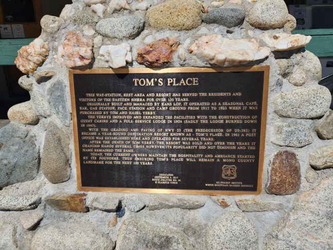
This way-station, rest area and resort has served the residents and visitors of the Eastern Sierra for over 100 years.

Originally built and managed by Hands Lof, it operated as a seasonal cafe, bar, gas station, pack station and camp ground from 1917 to 1923 when it was purchased by Tom and Hazel Yerby.

The Yerbys improved and expanded the facilities with the construction of guest cabins and a full service lodge in 1924 (sadly the lodge burned down in 1947).

With the grading and paving of Hwy 23 (the predecessor of US-395) it became a year-round destination resort town known as – Tom’s Place. In 1961 a post office was established here and operated for several years.

After the death of Tom Yerby, the resort was sold and over the years it changed hands several times. However its popularity did not diminish and the name remained the same.

Today, the current owners maintain the hospitality and ambiance started by its founders. Thus ensuring Tom’s Place will remain a Mono County landmark for the next 100 years.

Dedicated
September 9, 2017
Bodie Chapter No 65
B Clampus Vitus

Location

8180 Crowley Lake Drive, Crowley Lake California 93546

37.5613° N, 118.6812° W

Emigrant Road, Jerome, ID

Emigrant Road Historical Marker, Jerome, ID

Known as the Emigrant Road, this route was favored by the Hudson’s Bay Company during the mid-1800s. The road ran from Snake River in the north to South-Central Idaho. As an alternative to the Oregon Trail, which tended to be difficult, the Hudson’s Bay Company traders used it to go between Fort Hall and Fort Boise.

Emigrants, on the other hand, had to take a route further south since the road was not initially designed to allow for wagons. With later improvements, emigrants would be able to use this route.

There is a dispute amongst historians as to whether this road was part of the North Alternate to the Oregon Trail, which would have made it part of the Oregon Trail System.

Historical Marker Inscription

More than a century ago, fur trappers and emigrants followed an old Indian trail that crossed here on its way to Oregon.

Hudson’s Bay Company traders preferred this route between Fort Hall and Fort Boise, but early emigrant wagons had to travel a road south of Snake River until ferries and road improvements let wagons come this way. Shoshone Falls — known until 1849 as Canadian Falls to British and French trappers — was a spectacular attraction along this road.

Location

42° 37’ 13.032” N, 114° 26’ 57.978” W
US-93 N, Jerome, ID  83338, United States

Leslie Jensen Scenic Drive Historical Marker, Hot Springs, SD

Leslie Jensen Scenic Drive Hot Springs SD Historical Marker

This highway along Fall River is dedicated to Governor Leslie Jensen. He was the Republican 15th Governor of South Dakota from January 5, 1937 to January 3, 1939.  He was a native of Hot Springs, South Dakota.  Jensen was known as the “father of the modern highway system in South Dakota”.

While successful in office, Jensen decided not to run for a second term as governor and instead ran for the U.S. Senate, but he was defeated in the primary. He served in World War I and World War II.  He was honorably discharged in 1945.

Historical Marker Inscription

This highway along Fall River is dedicated to Leslie Jensen, 15th Governor of South Dakota 1937-1939, a native of Hot Springs, and a son of Chris Jensen, Black Hills Pioneer and Lillie May Haxby Jensen. Educated in Hot Springs, Culver Military Academy and the University of South Dakota, he took an early interest in the Military and was a Lieutenant in the 4th South Dakota Infantry on the Mexican Border in 1916-17 and when that organization became the 147th Field Artillery in World War I, he went to France with it and was the Regimental Adjutant. Staying with the 147th, he was its Lieutenant Colonel in 1937 when, as Governor, he became his own Commander-in-Chief. Promoted to Colonel in 1941, he took his Regiment to the South Pacific in World War II and when the Regiment was battalionized in 1943, he served with distinction as a Base Commander on the staff of the Commanding General of the Sixth Army. In 1921 he was appointed Collector of Internal Revenue for the District of South Dakota serving until 1934 when he returned to Hot Springs and to the telephone business which his father had started in 1894. His administration, in 1937, initiated

Reverse Side

You Are Entering
Hot Springs,
Sites Of
National and State
Soldiers Homes

Location

1301 Fall River Rd, Hot Springs, SD  57747, United States
43° 25’ 8.892” N, 103° 27’ 31.680” W

Occoquan River Bridges, Occoquan, Virginia

Occoquan River Bridges Historical Marker, Virginia

The Town of Occoquan, whose name means “Head of the Waters” in Native American, is a historic district filled with small shops. The town was founded by Nathaniel Ellicott who built the first bridge here in around 1800.

The historical marker marks the bridge located downstream from Occoquan Dam, and it connects Old Ox Road with the small town. The original bridge was destroyed in 1972, and now there is a footbridge here.

Historical Marker Inscription

Occoquan founder Nathaniel Ellicott built the first bridge here c. 1800. The “Great Mail Route” from Washington to the south crossed here. In 1878 an iron Pratt Truss Bridge was erected. This bridge was on the main east coast north-south highway until 1928. Hurricane Agnes destroyed the bridge in 1972. Today’s foot bridge replaced it.

Location

River Mill Park, 458 Mill Street, Occoquan, Virginia, 22125 United States

38° 41′ 8.460″ N, 77° 15′ 45.180″ W

Tullis-Toledano House Historical Marker, Mississippi

Tullis-Toledano House Historical Marker, Biloxi, MS

The Tullis-Toledano Manor was once listed on the U.S. National Register of Historic Places. It was built around 1856 and was a red-clay brick Greek Revival home. The property also went by the name Toledano-Philbrick-Tullis House.

The property was built by Christoval Sebastian Toledano, who was a wealthy sugar and cotton broker in New Orleans of Spanish descent. The house was built as a vacation property for his second wife, Matilda Pradat. The property also included a servant’s quarter.

Matilda Toledano sold the home in 1886. It was sold a number of times before Garner H. Tullis of New Orleans bought it in 1939. Tullis was president of the New Orleans Cotton Exchange. He later sold the manor to the City of Biloxi in 1975 who used it as a museum and community center.

In 1969, the home had been damaged by Hurricane Camille. It was destroyed by Hurricane Katrina on August 29, 2005 when a barge was pushed ashore and reduced the property to rubble.

Historical Marker Inscription

One of the most substantial of the early vacation houses on the Gulf Coast, the Tullis-Toledano House was built in 1856 for New Orleans native Christoval Sebastian Toledano (1789-1869) and his wife, Matilda Pradat Toledano. The estate, composed of a Creole-influenced Greek Revival house, detached kitchen, servants quarters, and carriage house, was purchased by the Tullis family in 1939. Damaged during Hurricane Camille and later restored, the house was destroyed by Hurricane Katrina in 2005.

Mississippi Department of Archives and History, 2013

Location

30° 23′ 33.780″ N, 88° 52′ 10.002″ W

Beach Boulevard, Biloxi, MS 39530 United States

Fort Union National Monument 1851-1891

Fort Union National Monument Historical Marker, NM

Fort Union was the largest military fort in the 19th century in the American Southwest. It was established in 1851 to protect the Santa Fe Trail and lasted for 40 years. The fort was actually three different forts with the third and last fort being the largest of the three.

Fort Union acted as a military supply depot, military garrison and territorial arsenal for the entire region.

Besides the remains of the fort, visitors can also see Santa Fe Trail ruts.

Historical Marker Inscription

Once the largest post in the Southwest, Fort Union was established to control the Jicarilla Apaches and Utes, to protect the Santa Fe Trail, and to serve as a supply depot for other New Mexico forts. The arrival of the railroad and the pacification of the region led to its abandonment in 1891.

Location

35° 44′ N, 105° 2.717′ W.

Traveling North on Interstate 25, Mile Marker 360, near Las Vegas, New Mexico

Ralph Carr Memorial Highway

Ralph Carr Memorial Highway Historical Marker Colorado

In the same place as the South Park historical marker on 285 at Kenosha Pass is another marker dedicated to Ralph Carr, a former governor of Colorado. Serving during World War II, Carr was the only Western governor to oppose the internment of Japanese Americans after the bombing of Pearl Harbor. He even gave speeches and wrote a letter published in the Pacific Citizen newspaper of the Japanese American Citizens’ League to encourage Japanese Americans to come to Colorado.

While only serving as governor for one term due to his resistance to the internment push, he did make Denver a popular postwar destination for Japanese Americans after they were released from internment camps. There was a large Japanese contingent in Colorado from the 1950s to the 1960s.

Carr’s support for Japanese Americans cost him the governorship, and he lost a Senate campaign in 1942. He tried running for Colorado governor again in 1950, but died right before the election at 62 years old.

Historical Marker Inscription

Ralph Carr Memorial Highway in Commemoration of Ralph L. Carr Governor of Colorado (1939-1943)

Following the attacks of Pearl Harbor, tens of thousands of Japanese Americans were forcibly sent to internment camps by the federal government. These Americans lost their property, possessions and freedoms unjustly and without due process. Defying overwhelming popular sentiment, Governor Ralph Carr defended U.S. citizens of Japanese ancestry. His convictions were clear:

“When it is suggested that American citizens be thrown into concentration camps, where they lose all privileges of citizenship under the Constitution, then the principles of that great document are violated and lost.”

Governor Carr’s brave and unpopular stand would cost him his political career but earned him the enduring respect of generations of Coloradans.

“…one voice, a small voice but a strong voice, like the voice of a sandpiper over the roar of the surf.” – Minoru Yasui “

Erected in accordance with a 2008 Resolution of the Colorado General Assembly.

This memorial was made possible through the financial support of the Colorado Asian Pacific American Bar Foundation and other private donors.

Dedicated October 2010

Location: US-285, Lake George, CO 80827

Latitude: 39° 24′ 12.432″ N Longitude: 105° 45′ 16.152″ W