This highway along Fall River is dedicated to Governor Leslie Jensen. He was the Republican 15th Governor of South Dakota from January 5, 1937 to January 3, 1939. He was a native of Hot Springs, South Dakota. Jensen was known as the “father of the modern highway system in South Dakota”.
While successful in office, Jensen decided not to run for a second term as governor and instead ran for the U.S. Senate, but he was defeated in the primary. He served in World War I and World War II. He was honorably discharged in 1945.
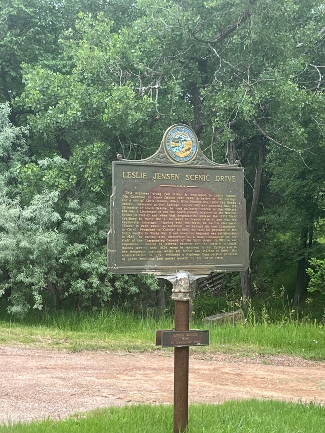
Historical Marker Inscription
This highway along Fall River is dedicated to Leslie Jensen, 15th Governor of South Dakota 1937-1939, a native of Hot Springs, and a son of Chris Jensen, Black Hills Pioneer and Lillie May Haxby Jensen. Educated in Hot Springs, Culver Military Academy and the University of South Dakota, he took an early interest in the Military and was a Lieutenant in the 4th South Dakota Infantry on the Mexican Border in 1916-17 and when that organization became the 147th Field Artillery in World War I, he went to France with it and was the Regimental Adjutant. Staying with the 147th, he was its Lieutenant Colonel in 1937 when, as Governor, he became his own Commander-in-Chief. Promoted to Colonel in 1941, he took his Regiment to the South Pacific in World War II and when the Regiment was battalionized in 1943, he served with distinction as a Base Commander on the staff of the Commanding General of the Sixth Army. In 1921 he was appointed Collector of Internal Revenue for the District of South Dakota serving until 1934 when he returned to Hot Springs and to the telephone business which his father had started in 1894. His administration, in 1937, initiated
Reverse Side
You Are Entering
Hot Springs,
Sites Of
National and State
Soldiers Homes
Location
1301 Fall River Rd, Hot Springs, SD 57747, United States
43° 25’ 8.892” N, 103° 27’ 31.680” W