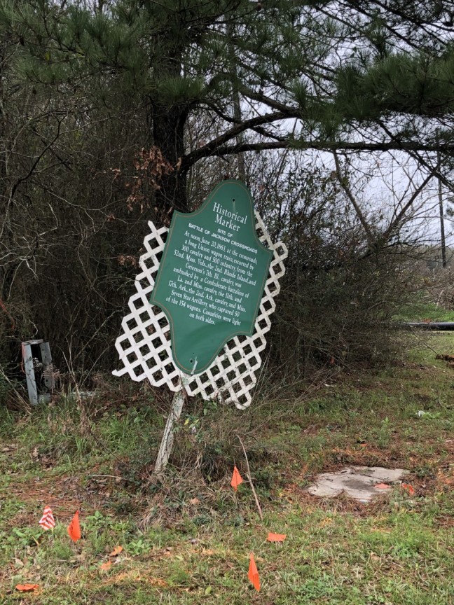
If you’re driving into Jackson, Louisiana, you might miss this historical marker. It sits near a light and is nearly tumbling over. But this hidden marker (green with a white picket fence background) marks the spot of a battle of the Civil War. In fact, Civil War reenactors regularly re-enact this battle on a field off Highway 68 near the original battle location.
The Historical Facts
Jackson was actually the location of two Civil War battles during 1863. The Union was trying to siege Port Hudson. This 48-day siege took place from May to July of 1863 when the Union was trying to recapture the Mississippi River so the Confederacy wouldn’t be able to use the river to transport supplies. While the siege failed, the river was eventually taken by the Union after Vicksburg fell.
Benjamin Henry Grierson, whose cavalry took part in the Battle of Jackson Crossroads, was known for the “Grierson’s Raid”, which was an expedition through Confederate holdings that successfully severed enemy communication lines between Vicksburg, Mississippi, and leaders in the East.
Historical Marker Text
“At noon, June 20, 1863, at the crossroads, a long Union wagon train, escorted by 300 cavalry and 500 infantry, from the 52nd. Mass. Vols., the 2nd. Rhode Island, and Grierson’s 7th. Ill. cavalry, was ambushed by a Confederate battalion of La. and Miss. cavalry, the 11th. and 17th. Ark., the 2nd. Ark. cavalry, and Miss. Seven Star Artillery, who captured 50 of the 154 wagons. Casualties were light on both sides.”
Location: 30.8374° N, 91.2176° W
Jackson, LA 70748 East Feliciana Parish. It is located at the intersection of Charter Street (State Highway 10 and Carrs Creek Road (State Highway 68) at the stoplight.