Blog

An Indian Deed, Sharpsburg, Maryland

An Indian Deed Historical Marker, Sharpsburg, MD

This marker commemorates one of the first recorded events in the area. It was a deed given to Israel Friend by local Native Americans in 1727. Friend had been a fur trader and was of Swedish ancestry. He and his family migrated to the American Colonies (at that point) in 1648.

According to legend, the deed was recorded on a piece of birch park. It was later recorded on the deed book for Prince George’s County.

The Native American signatures consisted of pictographs. One chief was from the Iroquois Nation, and five were from the Conestoga tribes. This deed marks one of the earliest incursions by white men into the area.

Friend didn’t hold the property for long. It was confiscated by the State of Maryland in 1734.

Historical Marker Inscription

Israel Friend in 1727 secured a deed from the Indian chiefs of the Five Nations. Beginning “at the mouth of Andietum Creek thence up the Potomack River 200 shoots as fur as an arrow can be slung out of a bow” thence “100 shoots right back from the river” then “squared till it interceeds with the creek.”

Location

39° 24’ 59.850” N, 77° 44’ 31.770” W
Harpers Ferry Rd, Sharpsburg, MD  21782, United States
Near Antietam at the intersection of Limekiln Road and Harpers Ferry Road.

The Berry Family Historical Marker, Glendale, UT

The Berry Family Historical Glendale, UT

Originally called Berryville, Utah, the site had been settled in 1862. The first group was led by John and William Berry. Later the area came to be known as Glendale. While initially only a simple water power mill was developed on the site, due to Native American incursions, a stockade was built in 1865.

By 1866, all settlements throughout Kane County, including Berryville, were vacated due to conflicts with the Native Americans. Robert Berry, Isabella Berry, wife of Robert Berry, and Joseph Berry were killed by Native Americans on Short Creek.

The area was resettled in 1871 by settlers from the Muddy Mission in Nevada.

Historical Marker Inscription

Four early Church pioneers, sons of Jesse Woods and Amelia Shanks Berry, were the founders of Berryville, now Glendale, Utah. Joseph S. and Robert M. and his wife Isabelle Hale Berry, were killed by Indians April 2, 1856. They are buried in Grafton, near Rockville. A mob shot and killed William Shanks Berry while on a mission in Tennessee in 1884. John William, while carrying mail for Brigham Young, was shot by an Indian and carried the bullet until his death.

A large and faithful posterity live to honor them.

Location

37° 19’ 6.000” N, 112° 35’ 51.558” W
25 N Main St, Glendale, UT  84729, United States

Pipe Spring National Monument Historical Marker

Pipe Spring National Monument Windsor Castle Arizona

Located on the Arizona Strip, Pipe Spring National Monument lies on very arid land. But water exists here. The area benefits from the rain and snowmelt from central Utah’s high plateau. Water flows down into a hard shale layer and then moves to the base of Arizona’s Vermillion Cliffs. Here, it is pushed to the surface. Pipe Spring is one of the locations where this happens.

Because water is so vital to so many people, many different types of groups were sustained by this spring. For over 12,000 years, this area has been frequented by everyone from nomadic hunters to the Ancestral Puebloan people to the Church of Jesus Christ of Latter-Day Saints.

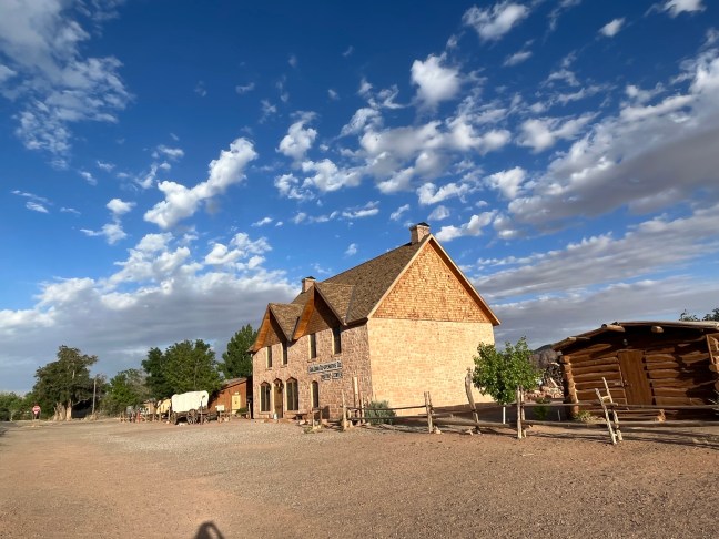
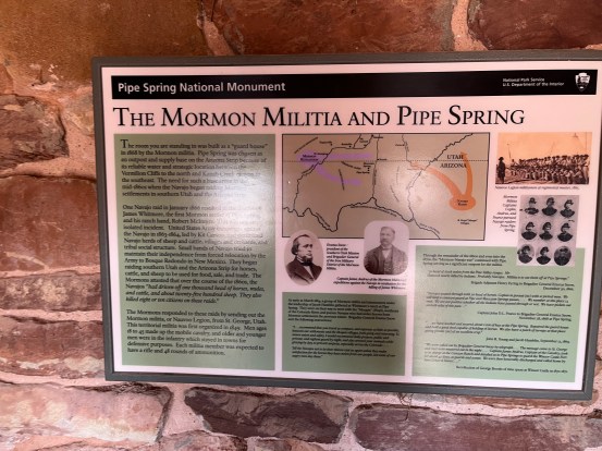
It was the Mormon pioneers who built the buildings in the national monument. They began occupying the area in the late 1850s. Their control of the springs brought them into conflict with the Paiute and Navajo Native American tribes. The Mormons had moved sheep and cattle into the area. This infuriated the Native peoples. The Navajo tribes raided the livestock, and in 1866, James Whitmore was killed trying to recover his lost livestock.

In 1868, Mormon militiamen built a stone cabin to protect against the raids. Later, under Brigham Young, they created a ranch here. It served as both a successful business and as a refuge for Mormon people seeking refuge against the anti-polygamy laws. The Mormons sold the ranch in 1895.

On May 31, 1923, Pipe Spring National Monument was created by President Warren G. Harding.

Pipe Spring National Monument Historical Marker Arizona

Historical Marker Inscription

PIPE SPRINGS NATIONAL MONUMENT
Established May 31, 1923
Through efforts of Stephen T. Mather and friends.

PIPE SPRINGS
Occupied in 1863, by Dr. James M Whitmore, who, with Robert McIntire was killed 4 miles S.E. of Pipe Springs January 8, 1866, by Navajo and Piute Indians.

WINDSOR CASTLE
Erected by direction of Brigham Young in 1869-70 by Anson Windsor for handling the Church tithing herds and as a frontier refuge from Indians. It became the first telegraph office in Arizona when the Deseret Telegraph Line reached here in December 1871.

Utah Pioneer Trails and Landmarks Association and Citizens of Kanab Stake
Pipe Spring National Monument

Location

36° 51’ 47.652” N, 112° 44’ 22.122” W

Pipe Spring National Monument, Ridge Trail, Valentine, AZ  86437, United States
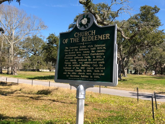
Church of the Redeemer Biloxi, Mississippi Historical Marker

Church of the Redeemer Historical Marker, Biloxi, MS

The Church of the Redeemer was built in 1874 and initially sat on the corner of Howard Avenue and Nixon Street in Biloxi, MS. The congregation had received its charter from the Mississippi Legislature in 1853. It was officially admitted to the Diocese in 1859. After its construction, it was the first Protestant church in the area.

Later in 1891, the church was moved to Beach Boulevard on land donated by Harry T. Howard. Known as the new church, it was used for 78 years until it was destroyed by Hurricane Camille on August 17, 1969. Both the church and the rectory were taken out by the hurricane. The bell tower and original “old church” survived, the latter with significant damage.

The old church was later repaired, and service was held there on Christmas Eve 1969. The church survived until Hurricane Katrina hit the area on August 29, 2005. It destroyed the remaining church and bell tower.

Historical Marker Inscription

The Carpenter Gothic style Episcopal Church of the Redeemer, built 1873-74, was located here. Among the church’s parishioners was former Confederate President Jefferson Davis. In 1892, a new church, designed by architect Thomas Sully, was constructed south of the original building. Only the belltower of the 1892 church survived Hurricane Camille in 1969. Both it and the older church were destroyed by Hurricane Katrina in 2005.

Mississippi Department of Archives and History, 2014

Church of the Redeemer Historical Marker, Biloxi, MS

Location

30° 23’ 36.498” N, 88° 52’ 54.690” W

612 Beach Blvd, Biloxi, MS  39530, United States

Replica of the Bluff Meeting House, Bluff, Utah

Replica of the Bluff Meeting House Bluff Utah

The Bluff meetinghouse was part of the Bluff Fort. Initially, residents would meet under an old cottonwood tree near the San Juan River. When a swing was attached to the tree, it become known as the “Swing Tree”. Later, the people realized that they needed a better place to meet so the meetinghouse was built at the end of 1880.

At first, it was a double-length cabin. It later was expanded with a new section to make it larger. Besides a meetinghouse, it was also used as a schoolhouse, community center and courthouse.

The Bluff Fort was built along a wagon road established by Mormon pioneers. It was part of the “Hole-in-the-Rock Expedition” which began in 1879. The goal of the expedition had been to create a mission at Montezuma along the San Juan River. The pioneers decided to use a route known as the “Escalante shortcut” believing that the journey would take six weeks. In reality, it took 6 months and 260 miles on the Hole-in-the-Rock Trail.

Since the trail was not designed for wagons, it had to be chiseled and blasted open in the Hole-in-the-Rock sandstone cliffs. After traveling for months, the pioneers decided to not pursue the last 20 miles to the intended location. Instead, they settled in the area that would become Bluff City in 1880.

Replica of the Bluff Meeting House Bluff Utah

Historical Marker Inscription

Sketched by Remington Lange 1893

Bluff’s log meetinghouse was the center of all public gatherings for the small community on the remote San Juan frontier. The meetinghouse, which was part of the north wall of the Bluff Fort, served as chapel, courthouse, ballroom, concert hall and schoolhouse. It was a place where pioneers were entertained with dances, dramatizations and musical performances. It was also a place of worship and learning, and on occasion, it sheltered families whose mud roofs failed to keep the rain out or whose cabins were flooded by the river. The meetinghouse was built in the latter part of 1880. “It offered a handy place for friends to meet, and for strolling lovers to rest in the evening. …not just a church, but simply a meetinghouse, vested with all essentials for solemn worship, but not too good nor too nice for any lawful service to the busy pioneers.” On Christmas, “…children thronged the old log school house during the day, and the place became the scene of many a merry party in long winter evenings.” —Albert R. Lyman

This site is being developed and maintained by the Hole-in-the-Rock Foundation

Location

37° 17’ 3.582” N, 109° 33’ 10.968” W

550 Black Locust Ave, Bluff, UT  84511, United States

Enough Water to Go Around? Guernsey, Wyoming

Enough Water to Go Around Hartsville Wyoming Historical Marker

The Platte River starts in the Colorado Rockies at Grizzly Creek, Colorado. It has two forks: the North Platte and the South Platte. The South Platte River flows through Colorado and its major city Denver. The other tributary flows through Wyoming. The two forks connect in Nebraska. The river is 310 miles long.

During the 1800s, it served as one of the main routes that pioneers used to travel to the west. It also acts as part of the continental bird migration route.  It is estimated that as many as 500,000 sandhill cranes and a percentage of whooping cranes migrate through the central Platte area.

Over the years, the North and South Platte river waters have been diverted for use in reservoirs, dams and more. This means that the amount of water that actually flows in the river has fallen. This has increased plant life along the rivers and decreased bird habitat.

Historical Marker Inscription

The Platte River has two forks, both originate in the high Colorado Rockies. This is the north fork of the Platte. The north fork and south fork join in western Nebraska and eventually flow into the Missouri River. As human populations have grown throughout the world, so has their need for water. Platte River water irrigates croplands in Wyoming, Colorado, and Nebraska — part of our nation’s breadbasket. It provides drinking water for over four million people and as many domestic animals. Competition for this water is fierce. Fish and wildlife also rely on this water to survive. Upstream and downstream wildlife use the water from the river for drinking and as a home. It is particularly important as a resting place for millions of ducks and geese as well as the nation’s largest single gathering of sandhill cranes. Vegetation growing along the river’s banks is lush because of the deep soils and available water. This vegetation, when protected and conserved, grows deep roots which hold river bank soils together, keeps the river from eroding the banks and filters soil out of the water before entering the river. River bank vegetation helps keep the river water clean for humans, fish, and wildlife.

All humans along the Platte are responsible for the river’s water. We control the destiny of humans and wildlife on the Platte. Part of our responsibility to Wyoming’s resources is its wild places and wild things.

Location

1950 US-26, Hartsville, Wyoming 82215 United States

42° 15′ 40.352″, 104° 41′ 49.548″ W

Marsalis Mansion Motel Historical Marker, Louisiana

Marsalis Mansion Hotel Historical Marker, Jefferson, Louisiana

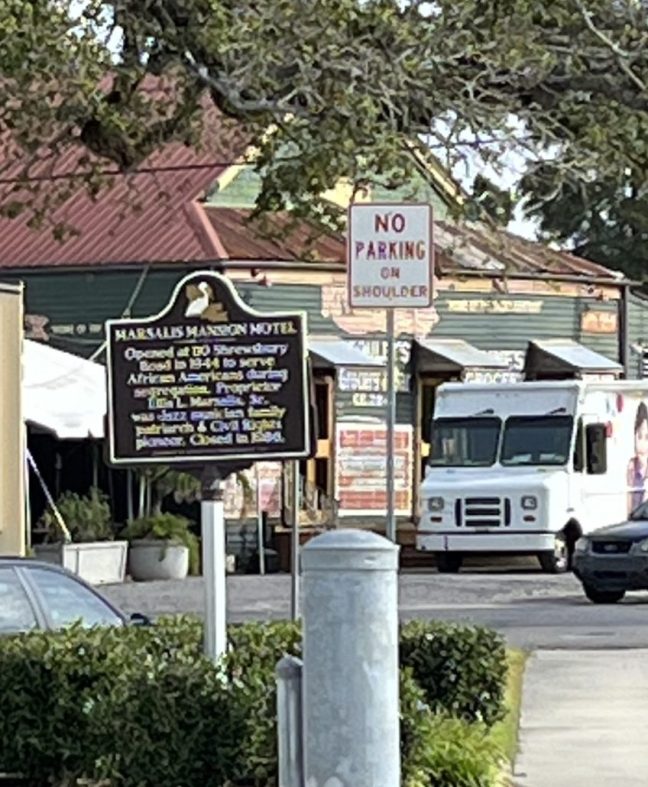
The Marsalis Mansion Motel opened in 1943 in a converted chicken barn. The motel was owned by Ellis Marsalis, Sr., the patriarch of the New Orleans jazz musical family. It offered luxury accommodations to African Americans during segregation. Located on River Road in Jefferson Parish, the motel hosted many famous guests, including Rev. Martin Luther King Jr., Ray Charles and Thurgood Marshall.

During the 1950s, the nightclub, the Music Haven, was located on the motel’s grounds. The motel closed in 1986 and was condemned in 1993 and razed. The historical marker was dedicated in 2015.

Historical Marker Inscription

Opened at 110 Shrewsbury Road in 1944 to serve African Americans during segregation. Proprietor Ellis L. Marsalis, Sr., was Jazz musician family patriarch & Civil Rights pioneer. Closed in 1986.

Location

3511 River Road, Jefferson, Louisiana 70121, United States

29° 57′ 28.350″ N, 90° 9′ 42.660″ W

Whitehall Plantation Home, Louisiana

Whitehall Plantation, Louisiana Historical Marker

Whitehall Plantation was built in 1857 for Francois Pascalis de la Barre and his family. Covering 8,000 acres, it extended from the Mississippi River to Lake Pontchartrain. It was a sugar plantation until 1891. During the American Civil War, it operated as the headquarters for Union troops.

Starting in 1919, it served as a gambling casino. Later in 1935, it was turned into the Magnolia School for those with special needs and intellectual and developmental challenges. The school still operates today.

Historical Marker Inscription

Built in 1857 for François Pascalis de Labarre IV. Occupied by Union Troops during the Civil War. After 1892 was a gambling casino, Jesuit retreat house and St. Agnes Church. Magnolia School since 1935.

Location

100 Central Avenue, Jefferson, Louisiana 70121, United States

29° 57′ 9.018″ N, 90° 10′ 7.158″ W

Occoquan River Bridges, Occoquan, Virginia

Occoquan River Bridges Historical Marker, Virginia

The Town of Occoquan, whose name means “Head of the Waters” in Native American, is a historic district filled with small shops. The town was founded by Nathaniel Ellicott who built the first bridge here in around 1800.

The historical marker marks the bridge located downstream from Occoquan Dam, and it connects Old Ox Road with the small town. The original bridge was destroyed in 1972, and now there is a footbridge here.

Historical Marker Inscription

Occoquan founder Nathaniel Ellicott built the first bridge here c. 1800. The “Great Mail Route” from Washington to the south crossed here. In 1878 an iron Pratt Truss Bridge was erected. This bridge was on the main east coast north-south highway until 1928. Hurricane Agnes destroyed the bridge in 1972. Today’s foot bridge replaced it.

Location

River Mill Park, 458 Mill Street, Occoquan, Virginia, 22125 United States

38° 41′ 8.460″ N, 77° 15′ 45.180″ W

Jack M. Campbell Historical Marker, Taos, NM

Jack M Campbell Historical Marker

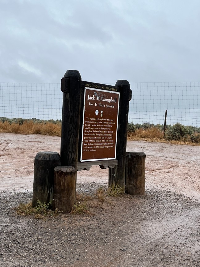
Governor Jack M. Campbell was a Democratic governor of New Mexico from 1963 to 1966. He was elected as governor on November 6, 1962, and again in 1964. He was also part of the New Mexico House of Representatives from 1955 to 1962, serving the last two years as speaker.

This stretch of U.S. 64 was named in honor of him by the members of the New Mexico State Highway Commission on September 23, 1965.

Historical Marker Inscription

Taos to Tierra Amarilla

This road passes through some of the most spectacular scenery in the American Southwest. It is a key section of the east – west highway which brings visitors to this region from throughout the United States. Since this route became a reality through the leadership and perseverance of Governor Jack M. Campbell (1963-1966), the members of the New Mexico State Highway Commission voted unanimously on September 23, 1965 to name this portion of U.S. 64 in his honor.

Location

El Prado, New Mexico 87571, United States

36° 30′ 38.400″ N, 105° 39′ 24.642 W