Blog

Wagon Mound, NM

For travelers along the long Santa Fe Trail, landmarks ensured that they were going in the right direction. One such landmark was the nearly 7,000-foot butte known as Wagon Mound, which was named due to its shape and the fact that it kind of looked like a covered wagon. It signaled the location of the Cimarron Cutoff, which was a settlement route that connected St. Louis, MO, and Santa Fe, NM.

Wagon Mound told travelers two things. It was the last major landmark before getting to Santa Fe and the end of their journeys. Two, it meant that there was a water source nearby in the Santa Clara Canyon. But, groups had to be careful in this area because there were hostile Native Americans in Santa Clara Canyon.

The route that took travelers near this landmark was popular from about 1822 to the 1870s.

Historical Marker Text

This last great landmark on the Santa Fe Trail was named for its resemblance to the top of a covered wagon. At Wagon Mound, travelers could cross from the Cimarron Cutoff to Fort Union, which is located on the Mountain Branch of the Trail. The two branches joined south of here at Watrous.

Location: 36° 0.697′ N, 104° 42.393′ W in Wagon Mound, NM, at the intersection of State Road 120 and I-25.

Jemez Mountains, NM

The Jemez Mountains are the remnants of a super volcano, whose last major eruption was about 1 millions years ago. Fewer, smaller eruptions have occurred since this last catastrophic one. While these mountains sit within the Rocky Mountains, they are geologically distinct from this mountain range.

IMG_3798

Many of the area points of interest, including Bandelier National Monument, are located on top of the ash flow from this volcano. You can also see the 13-mile wide circular depression created by the volcano at Valles Caldera National Preserve.

Text From the Historical Marker

IMG_3799

Side 1: On the skyline to the west are the Jémez Mountains where tremendous volcanic eruptions a million years ago created a huge caldera some 15 miles in
diameter that now forms beautiful Valle Grande set amid a ring of volcanic peaks. Geothermal energy has been tapped from hot rock beneath the
mountains. The Jemez Mountains are part of the Southern Rockies and form one of the western ranges of the Rockies in New Mexico. Elevations exceed 11,000
feet.

Side 2: Flow and ash-fall deposits surrounding the volcanic range form the Pajarito Plateau, site of numerous ancient cliff dwellings preserved at Bandelier National Monument and Puye Cliff Dwellings. Part of the plateau was homesteaded by Hispanic families until 1943 when the U.S. government condemned their land and the private Los Alamos Ranch School for the Manhattan Project. Los Alamos National Laboratory and the city that grew up around it are built over the homesteads and the school is a museum.

Location: Off Highway 502 in Santa Fe County between Santa Fe and Los Alamos. Latitude: 35.885887 N Longitude: 106.102225 W

New Mexico Highlands University

Located in Las Vegas, NM, New Mexico Highlands University was established by the Territorial Legislature in 1893 as the New Mexico Normal School. With the region booming due to the arrival of the Santa Fe Railroad in the 1870s, the area decided that it needed an institution of higher learning. It officially opened in 1898, and archaeologist Edgar Lee Hewett was the school’s first president.

What started as a school of 92 students and 6 faculty members quickly grew into a larger institution. Enrollment increased to over 300 in 1901. It’s name changed in 1902 to New Mexico Normal University and then again to New Mexico Highlands University in 1941.

By 1917, the school was offering four-year teacher training programs.

IMG_3894

New Mexico Highlands University Today

Today, the school has nearly 4,000 students, mainly from New Mexico and of Latino descent. The school is known for its multi-ethnic student body and offers programs in business, education, arts and sciences, and social work.

Location: 1005 Diamond St, Las Vegas, NM 87701 35.5933° N, 105.2223° W

The Greatest Ride in History

Wyoming Historical Marker Near Fort Laramie: Greatest Ride in History

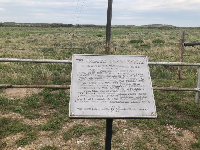
Right outside of Fort Laramie is a historical marker commemorating a horse. While that might sound odd to many people, it’s actually one of the more interesting stories of Fort Laramie and Fort Kearny.

Background to the Ride

Fort Laramie had been the main outpost of the U.S. Government on the Northern Plains. For many years, it was the main meeting point between the government and the sovereign tribes of the Northern Plains, and many treaties had been signed there, including the Fort Laramie Treaty of 1851, which designated the territory near the fort as Crow land (west of the Powder River).

While the Lakota, Cheyenne and Arapaho had initially accepted the agreement, as the buffalo herds became reduced, they soon began invading Crow land. By 1860, these three tribes had taken over this land.

In June 1866, United States Colonel Henry B. Carrington left Fort Laramie and moved into the area now controlled by these three tribes. He was charged with protecting civilians traveling along the Bozeman Trail. Along this trail, he established Fort Phil Kearny and two other posts.

As the new fort was being constructed, conflict rose between the Native American warriors and the army. On November 3, 1866, a group of cavalry showed up at the fort to reinforce the post. They were led by Lieutenant Horatio S. Bingham and Captains William J. Fetterman and James W. Powell. Carrington had refused to take the offensive, which led to Fetterman criticizing him.

Carrington was eventually forced to take the offensive on November 25, 1866 when his superior ordered him to do it. On December 6, Carrington took the fight to the Native Americans, but suffered great losses, including the death of Bingham. Sobered by this, Carrington became more cautious. The Natives led by Red Cloud, the Oglala Lakota leader, had used a decoy to draw the army into a trap.

Fight on December 21, 1866

Encouraged by their success, Red Cloud decided to attack Fort Kearny. Sent to get timber and firewood for the fort, a wagon train was in an area about five miles away. The Native Americans attacked the train, and Carrington ordered soldiers to help fend off the attack. While Powell was initially in charge, Fetterman claimed seniority and took the lead.

Carrington had told the party not to pursue the Native warriors over the ridge. Fetterman ignored the command and chased the Native Americans over Lodge Trail Ridge. The Fetterman’s and 80 of his men’s bodies were later found mutilated. Wagons were sent to retrieve the bodies.

The Ride of a Lifetime

Because of Fetterman’s folly, more than one-quarter of the fort’s fighting men had died. The garrison was low on quality rifles and ammunition. There were still thousands of warriors in the area.

Carrington asked for civilian volunteers to ride out and ask for reinforcements. John “Portugee” Phillips agreed to do the ride. In the bitterly cold, blizzard-laden night, Phillips took the commanding officer’s own horse and rode out into the night. He arrived at the Fort Laramie parade ground on Christmas night during a full-dress garrison ball.

The Spot Where John "Portugee" Phillips Arrived at Fort Laramie

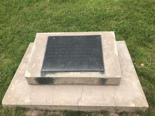
He quickly told the story of the Fetterman massacre and how Fort Kearny needed their help. Phillips horse died from exhaustion shortly after arriving at Fort Laramie. It had gone 236 miles in two days in a blizzard and freezing conditions.

Site of Santa Fe’s First Chapel

Santa Fe, New Mexico Historical Marker: First Chapel

Santa Fe is a mecca of history, so there are plenty of historical markers in the area. On the southeast corner of the Place of the Governors lies the historical marker for Santa Fe’s first chapel.

According to the marker, the chapel was “Also used as two story defensive tower for Palace of the Governors during the 1600’s. Gen. Don Diego de Vargas was probably buried beneath the floor of this chapel in 1704”. The chapel was demolished in 1774.

Don Diego de Vargas

Diego de Vargas Zapata y Luján Ponce de León y Contreras, better known as Don Diego de Vargas, was a Spanish Governor of the territory of Santa Fe from most of the 1690s until 1704. He was in charge of the reconquest of the New Mexico territory after the Pueblo Revolt in 1692.

The Pueblo Revolt started in August 1680, and involved Pueblo people from different pueblos. While traditional extremely peaceful people, the Pueblo people were treated cruelly by the Spanish rulers. They overthrew Spanish rule in New Mexico and held the area for more than 12 years.

Location: N 35° 41.261 W 105° 56.266

Dominguez Y Escalante Expedition 1776 – 1976

Located in Marble Canyon on Highway U.S. 89A at mile post 557, this spot commemorates a portion of the Dominguez y Escalante Expedition. While the marker itself is missing, you can see the stone holder of where it used to be.

Father Silvestre Velez Escalante and Father Francisco Atanasio Dominguez were co-leaders of an expedition, along with 10 companions, that left Santa Fe, NM, to try and a find a route to Monterey, CA. The Dominguez-Escalante Expedition began in July 1776, but was having trouble less than 10 weeks after leaving Santa Fe.

Near Thermo Hot Springs in Utah, they ran into a blizzard, and supplies were running short. The members of the crew drew lots to determine whether they should try to continue forward or turn back to Santa Fe. The outcome was that they turned around and were back in Santa Fe on January 2, 1777.

Dominguez-Escalante Expedition Historical Marker

Located near the Vermillion Cliffs, according to the Historical Marker Database, this marker memoralizes the following:

Within sight of this place the Franciscan priests Dominguez and Escalante and their ten companions experienced two of the most difficult challenges among many along the 1,800 miles of their epic journey from the Spanish presidio at Santa Fe, New Mexico.

IMG_0745

Major Powell, Colorado River Explorer

John Wesley Powell was a geologist and explorer of the American West. He had also been a soldier for the Union Army during the American Civil War. Powell, however, is most well-known for his series of expeditions throughout the Rocky Mountains and the Green and Colorado Rivers.

In 1869, Powell and nine other members of his team set out into the West to explore both the Colorado River and the Grand Canyon. They had four boats and enough food for 10 months for their trip through Utah. Only six crew members made it all the way through the expedition. One quit early in the journey and three left right before the crew reached the mouth of Virgin River on August 30, 1869, where the journey ended.

The three men who quit headed out at Separation Canyon and were never seen again. There has been speculation for years as to what happened to these three. Because they were never found, many of Powell’s journals were lost because they had been sent out with them. We recently heard a story that a journal had been discovered by a young Mormon girl who wrote about three men entering their village. The elders took these three out of village, and nothing more was written.

The Marker

The Powell historical marker is located 1084 East Main Street in Elgin, UT – right in front of the Motel 6. Here is what is engaged on it:

The first organized attempt to conquer the swirling rapids and precipitous walled canyons of the Green and Colorado Rivers was made by Major John Wesley Powell, Civil War hero and explorer. Warned by Indians and mountaineers they would never return alive, Powell and 9 companions started from Green River Station, Wyoming Territory, on May 24, 1869, with 4 boats, instruments for making scientific observations, and provisions to last 10 months. For 97 days Powell and his men battled the elements, enduring tremendous deprivation and hardship.

One man (Frank Goodman) left the company early in the journey, and 3 others (William Dunn, O.G. and Seneca Howland) later killed by Shivwits Indians, deserted near Grand Canyon, Arizona. On August 29, 1869, the 6 remaining men arrived at the junction of the Rio Virgin in southern Nevada, having navigated and charted over 900 miles of the river.

In May, 1871, 2 years after his first river voyage, J.W. Powell again led an exploring party of 11 men in 3 boats down the Green and Colorado Rivers. Well into 1873 members of Powell’s party continued extensive and significant exploration and surveys of the region bordering the rivers traversed. The Powell Surveys are some of the most significant explorations achieved anywhere in the world.

NW 1/4, NW 1/4, NE 1/4, Sec. 15, TWP 21S, R 15E

New Mexico Historical Marker: Mother Magdalen and the Sisters of Loretto


This marker is located in the downtown area of Santa Fe at the intersection of East Alameda Street and Old Santa Fe Trail. The marker commemorates Mother Magdalen Hayden and Sisters Roberta Brown, Rosana Dant and Catherine Mahoney, who established the Our Lady of Light Academy (which became known as Loretto). This was the first school for young women in the New Mexico Territory.

The Sisters also worked with the local people to raise funds from 1863 to 1879 to build the Loretto Chapel, which is known for its “miraculous staircase”, which is a marvel of construction because it has no visible means of support.

IMG_0031

Over the following century, hundreds of women, many who were of Hispanic decent, joined the Sisters of Loretto. The first native-born New Mexican superior of Loretto was Lucia Perea, who took over this position in 1896.

A note on the “A Catholic Mission” site provides a bit more information about Mother Magdalen:

“Joanna Hayden took on the name of Sister Magdalen Hayden when she took her vows to the Loretto Order in 1834. After spending time in Loretto, KY, Cape Girardeau and Bethlehem, MO, she entered the western missions.  In 1852, Sister Magdalen and a group of Loretto Sisters left the Kentucky Mother house for Santa Fe.  In route, the mother superior of the group died of cholera in Independence, MO.  Sister Magdalene became Mother Magdalene.  Mother Magdalene’s time in Santa Fe is well documented as the founder of several Catholic schools and the Superior of the Our Lady of Light Academy in Santa Fe, also known as the Loretto Academy.  The Loretto Academy in Santa Fe is very well known for the spiral staircase built during her time.”


Location: 35° 41.093′ N, 105° 56.279′ W

CO Historical Markers: Hardscrabble, Colorado

The village of Hardscrabble was established in the 1840s. Founded by traders and trappers, the town was located below the fork of the Hardscrabble and Adobe creeks. While little trace of the settlement still exists, we know that the walls and homes of the town were made of Adobe, creating a square to protect them against Native American attacks, especially from the Ute and Arapaho.

The Hardscrabble area attracted many Native American tribes, including Ute, Cheyenne, Arapaho, Sioux and Kiowa. According to the Wetmore Historical Society, Spanish explorers even came to the area in the 1600s in their search for gold and treasures. American, French and Mexican settlers, trappers and traders started coming to the area in the 1830s.

In 1844, Americans from El Pueblo created a trading post at San Buenaventura de los Tres Arrollos. This was about 5 miles northeast of Ft. LeDuc, which had been built around 1830 by French trappers who were seeking trade with Native Americans, settlers and mountain men. The name of the trading post was later changed to Hardscrabble.

The historical society indicates that:

According to George Simpson, one of its founders, the name came from the “hard scrabbling to get in a crop” in the gravelly soil. 

Tow of Hardscrabble in Custer County Colorado

The town of Hardscrabble traded with nearly anyone who passed through the area, but it wasn’t enough to sustain them. After only a few years of operation, Ft. LeDuc closed in the 1840s, and many residents of the surrounding areas left for the California gold rush.

For Hardscrabble itself, it’s location was a deterrent to success. It was far away from the Santa Fe Trail, and the community was tiny. By 1848, the community was nearly abandoned as observed by John C. Fremont and his men as they were passing through the area.

What’s left of Hardscrabble is located in Custer County. The historical marker is located off Highway 67 between the town of Wetmore and Florence: N 38° 15.872 W 105° 05.265.