Blog

Cows, Wildlife and Gold, Wyoming

Cows, Wildlife and Gold, Wyoming Historical Marker

The Cheyenne River, also known as Chyone, which refers to the Cheyenne people who once lived in the region, is a tributary of the Missouri River. In Lakota, it’s called ‘Wakpá Wašté’ (Good River). It is about 295 miles (475 km) long and drains an area of 24,240 square miles. It runs through eastern Wyoming and western South Dakota, and includes the Black Hills upland region. In fact, 60% of the drainage basin is located in South Dakota.

The Angostura Dam is located on the Cheyenne River near Hot Springs, SD. This project was finished in 1949. Via man-made reservoirs, the Cheyenne River is connected with the Missouri at Lake Oahe, a man-made reservoir.

Historical Marker Inscription

The Cheyenne River drainage system has been the locus of human activity for thousands of years. Native Americans used the corridor in search of wild game and wild plants resources. When gold was discovered in the Black Hills in 1875, miners, gamblers, freighters and road agents were among those following the Cheyenne-Deadwood road through this area. Stage coaches carried gold to the railroad in Cheyenne and brought passengers back. Robbers’ Roost, a creek crossing a few miles north of Mule Creek Junction, was a favorite spot for hold-ups. General George Crook and his men camped nearby on the Cheyenne River in June 1876 during the Powder River Campaign while Custer waged his battle at the Little Big Horn.

In the 1870s and 80’s thousands of cattle came, later followed by thousands of sheep – most of them trailed from Cheyenne. Ranches were built up in the late 1870s and 1880s. A few of them remain in the same family today. The Cheyenne River and its tributaries have water sources for pioneers, livestock, wildlife, and the irrigation of alfalfa fields.

Today most of the sheep are gone. Longhorn cattle were replaced by Herefords, and later by mostly Angus cattle. The short nutritious grasses of the area feed some of the best beef animals in the world. Calves are moved from these prairies in the fall to become beef for this nation and the world. Hunters come from throughout America to harvest the pronghorn antelope and mule deer made abundant by the rancher’s development of water and pasture.

Location

Mule Creek Junction Rest Area, Wyoming, Highway 18 and 85 – 45 miles from Lusk, Wyoming

N 43° 22.730, W 104° 13.257

Ione, Nevada

Ione, Nevada Historical Marker

While Native Americans lived in the land for 5,000 years, it was the Silver Rush that put Ione on the map. Founded in 1863 after silver was discovered in the Shoshone Mountain Range, it became a trade and milling center. When Nevada became a state in 1864, the town had a population of over 600 people, and it was the Nye County’s seat.

The town, however, didn’t last long. By 1867, the town of Belmont had attracted most of Ione’s residents away, and the county seat was moved to Belmont. In 1896, the town briefly boomed again when a 10-stamp mill was constructed. Later, in 1897, A. Phelps Stokes purchased much of the mining and milling interests in Union District, but by 1898, silver had dropped in value. Cinnabar deposits briefly brought prospectors to the area again from 1912 to 1914.

Ione General Store

While the town is largely deserted, it still hangs on. In fact, it’s known as the “Town That Refused to Die”.  It still has about 41 residents, but most of the businesses have ceased operations. It still has the claim to fame of being where the movie Tremors with Kevin Bacon was filmed.

Welcome to Ione Nevda

Historical Marker Inscription

American Indians lived in Ione Valley for at least 5,000 years.

In 1863, European Americans discovered silver, and in 1864, Ione City was the first county seat of the newly created Nye County. Over 600 people worked in the prosperous town until a promising ore body in Belmont attracted most of the miners in 1865, capturing the county seat in 1867.

Alternately prosperous and poor yet never completely deserted; Ione suffered mining depressions, milling difficulties, and the loss of miners to other rich strikes throughout its history.

Location

38° 56′ 58.338″ N, 117° 35′ 6.822″ W

SR-844, Round Mountain, NV 89409, United States

First Bryan Baptist Church, Savannah, GA

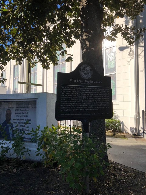
First Bryan Baptist Church Historical Marker Georgia

The oldest, continuous African American Baptist church in the U.S., the First Bryan Baptist Church was founded in 1788 by Andrew Bryan, a Savannah slave. He served as the first pastor of the church and later purchased the current site of the church after he purchased his freedom in 1793. He paid “30 pounds of silver” (about $150.00) for the land, and the original church building was constructed in 1795. The land where the church was built is located on land that originally was part of the Yamacraw Indian Village.

The current structure was constructed between 1873 and 1888, and it was designed by John B. Hogg. The stained glass inside the church features some of the founding fathers of the African American church.

First Bryan Baptist Church, Savannah, GA

Historical Marker Inscription

First Bryan Baptist Church
Constituted 1788

First Bryan dates its founding to the constitution of the Ethiopian Church of Jesus Christ under Rev. Andrew Bryan in January 1788, making it one of the nation’s oldest African-American Baptist churches. Known later as First Colored Church, First African, and Third African, the congregation took the name First Bryan Baptist in 1867. Construction of the first church building began here in 1793 on property purchased by Reverend Bryan. The current building was completed in 1874. First Bryan ministers including Garrison Frazier and Ulysses Houston attended the nearby meeting of local black leaders with Gen. Sherman in January 1865 that resulted in Special Field Orders No. 15, promising confiscated coastal land to freed slaves. In the twentieth century, Civil Rights leader W.W. Law taught Sunday School at First Bryan for many years.

Erected by the Georgia Historical Society and First Bryan Baptist Church.

“I Do” Fire, Maybell, Colorado

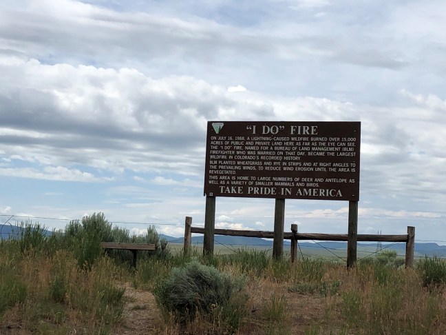
I Do Fire Colorado, Maybell, CO

Colorado is no stranger fires. They happen on a regular – and increasingly frequent – basis. The “I Do” Fire was one of the largest at the time. Currently, the largest Colorado wildfire in state history is the Cameron Peak fire, which burned over 208,000 acres.

Historical Marker Inscription

On July 16, 1988, a lightning-caused wildfire burned over 15,000 acres of public and private land here as far as the eye can see. The “I Do” Fire, named for a Bureau of Land Management (BLM) firefighter who was married on that day, became the largest wildfire in Colorado’s recorded history.

BLM planted wheatgrass and rye in strips and at right angles to the prevailing winds, to reduce wind erosion until the area is revegetated.

This area is home to large numbers of deer and antelope as well as a variety of smaller mammals and birds.

Take Pride in America

Location

U.S. Highway 40, West of County Road 143 approximately 5 miles from Maybell, Colorado

N 40° 28.999, W 108° 10.923

Grave of Colonel William A. Washington

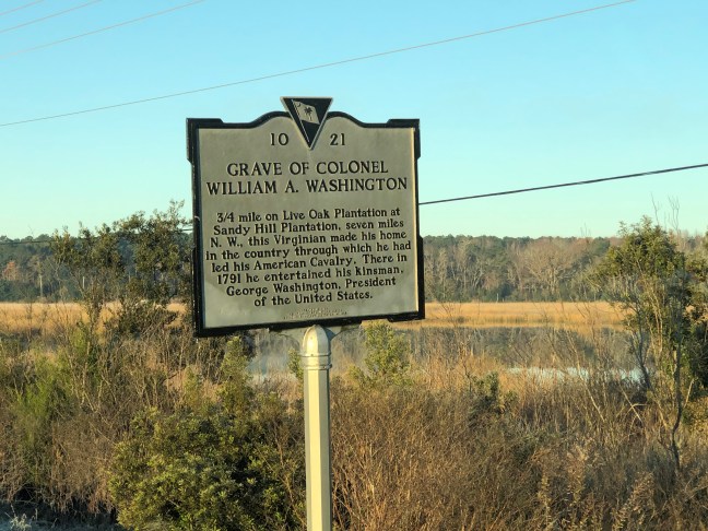
Grave of Colonel William Washington Historical Marker

William Washington was a distant cousin of George Washington. He was an officer of the Continental Army during the American Revolution. Lord Cornwallis even respected Washington, saying after the surrender at Yorktown, “there could be no more formidable antagonist in a charge, at the head of his cavalry, than Colonel William Washington”.

Born on February 28, 1752, he grew up with three brothers and two sisters on the family’s 1,200 acre-Virginia plantation, which had been located in Stafford County. When the Revolution started, he was elected as a Captain of the Stafford County Minutemen on September 12, 1775, which then became part of the Third Virginia Regiment in 1776. By the end of summer, the regiment joined the main army in New York. They were part of the Battle of Trenton on December 26, 1776. Captain Washington led a successful charge against Hessian soldiers.

By 1779, William Washington would become a lieutenant colonel, overseeing the Third Regiment of Continental Light Dragoons. Washington was instrumental throughout the war. In January 17, 1781, he led the charge that routed the British cavalry at the Battle of Cowpens.

On September 8, 1871, Colonel Washington was wounded and captured, and would spend the rest of the war as a prisoner of war in Charleston, SC. There, he would marry Jane Reily Elliott and obtain Sandy Hill Plantation. He became a low country planter. He was also elected as a representative to the South Carolina state assembly from 1787 to 1791, and later as a senator from 1792 to 1794 and 1802 to 1804.

As hostilities heated between the newly formed United States and France in 1798, President John Adams appointed Washington as Brigadier General under General George Washington.

William Washington died on March 16, 1810 after a prolonged illness.

Historical Marker Inscription

3/4 mile on Live Oak Plantation at Sandy Hill Plantation, seven miles N.W., this Virginian made his home in the country through which he had led his American Cavalry. There in 1791 he entertained his kinsman, George Washington, President of the United States.

Location

Savannah Highway (U.S. 17) near Waldon Road, Johns Island, South Carolina.

32° 47’ 42.972” N, 80° 8’ 10.790” W

Town of Occoquan, VA

Town of Occoquan Historical Marker, Virginia

The Town of Occoquan is a suburb of Washington, DC, located in Prince William County, Virginia. The name of the town of derived from the Algonquian Doeg Native American’s word for “at the end of the water”. Long before Europeans settled the Americas, the area was used by indigenous people, using the river for transportation and trade.

During the 1600s, Captain John Smith sailed alone the river, exploring the area. By 1734, the town had public warehouses for tobacco, and by 1749, iron furnaces were put in place along the river by Charles Ewell and John Ballendine. The first automated grist mill in the nation (Merchant’s Mill) operated in the area from 1759 to 1924 when it was destroyed by a fire.

In 1804, Town of Occoquan was formally established – located on the 31 acres that was owned by Nathaniel Ellicott, Luke Wheeler and James Campbell. It became an industrial town with the mills, forges, mercantile shops and shipping of railroad ties. During the 1890s, excursion boats from DC would bring tourists to admire the natural beauty of the area. The town, however, had begun to decline as an industrial town by the mid-19th century. Presently, the Occoquan is known as a destination for ghost walks, antiques, art, dining and more.

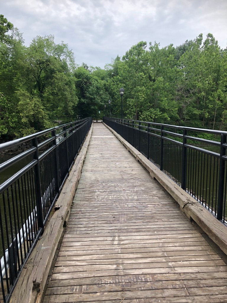
Bridge over Occoquan River, Virginia
Bridge over Occoquan River

Historical Marker Inscription

Nathaniel Ellicott formally established the town in 1804. Bringing to fruition industrial and commercial developments. Begun ‘at or near the falls of Occoquan’ by John Ballendine c. 1750 the estuary of the Occoquan has attracted the attention of travelers since the time of John Smith. Adjacent lands were patented by the 1850s; copper was being shipped from ‘King’ Carter’s Landing, and tobacco from a publish warehouse by the 1780s.

Prince William County Historical Commission – 1978

Location

203 Washington Street, Occoquan, VA 22125, US

38° 40′ 60.000″ N, 77° 15′ 34.518″ W

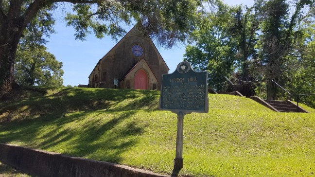
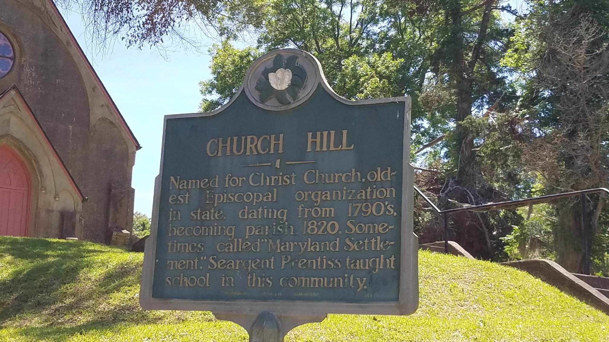
Church Hill Historical Marker

Church Hill, Mississippi

Church Hill, Mississippi, is named after Christ Church, which sits on a hill. The church was built around 1820 and is designed after county church buildings in England. It is located about 18 miles north of Natchez.

It was originally known as the Old Maryland settlement due to the people who moved from Maryland to Jefferson County after the Revolutionary War. The name was changed to Church Hill in 1820. Christ Church is often referred to as the “cradle of Episcopacy in Mississippi” since it was the first Episcopalian congregation in Mississippi.

During the height of the cotton boom, the area was home to many wealthy cotton planters before the Civil War. During the 1800s, however, soil erosion caused the decline. Antebellum plantations still lie along Highway 553.

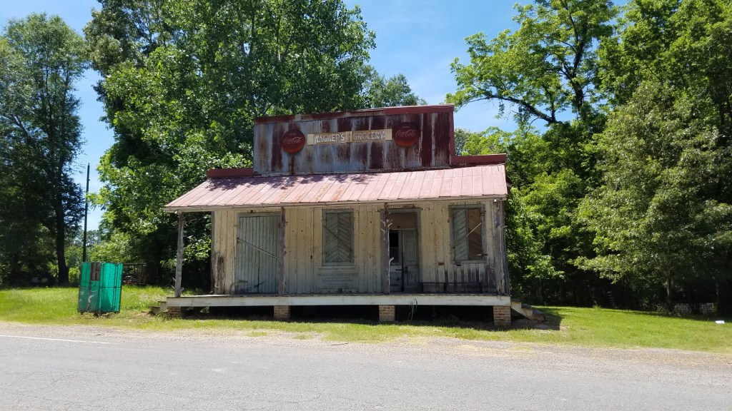
Wagners Grocery Store

One of the buildings still standing is Wagners Grocery, which was built around 1837. The store closed in 1998, and the building was donated to the Church Hill historic society. It was also a post office. It is believed to be the oldest heart pine country store that was also a post office in the Southeastern United States.

Historical Marker Inscription

Named for Christ Church, oldest Episcopal organization in state, dating from 1790s, becoming parish, 1820. Sometimes called “Maryland Settlement.” Seargent Prentiss taught school in this community.

Location

Intersection of State Highway 535 and Church Hill Road, Church Hill, Mississippi, USA

31° 42.946′ N, 91° 14.297′ W

Tybo, Nevada

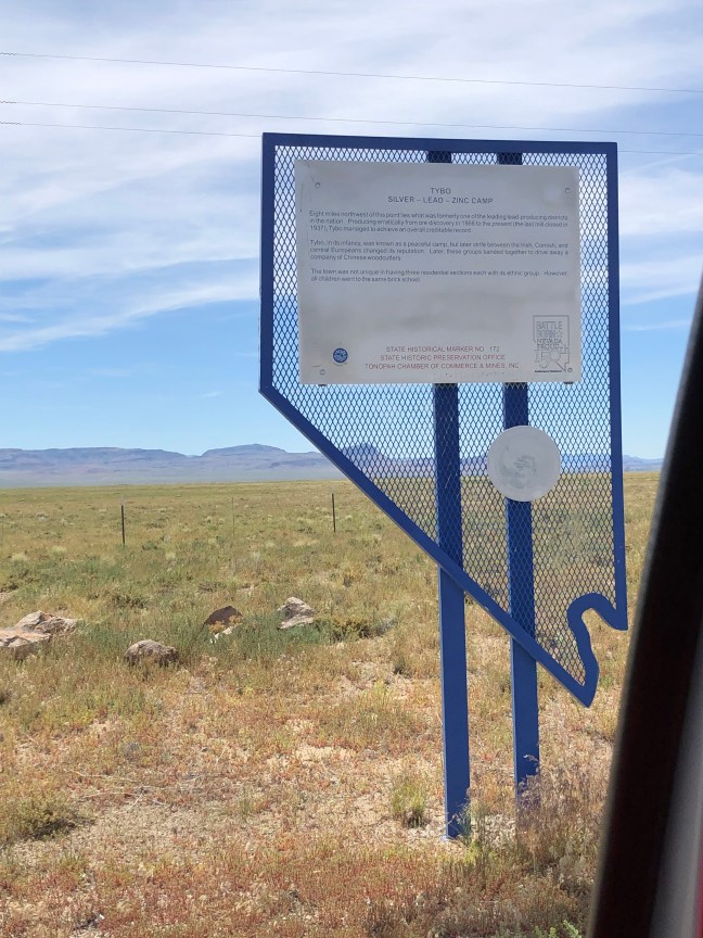
Tybo Historical Marker Nevada

White settlers first came to Tybo, Nevada, in 1865 or 1866 when a Native American led these people to a place where he had found gold ore in the Hot Creek mountain range. While some digging did occur at this time, the mining camp wouldn’t be established until 1871, and the smelter built in 1872. The town would finally be settled in 1874, and a lead smelter was added.

In 1875, the Tybo Consolidate Mining Company was created to manage the Two-G Mine, which was the largest producer in the area. By 1876, Tybo became a boom town with “around 1,000 residents, five stores, two blacksmith shops, a post office, and of course many saloons”, and, by the 1870s, the town became a leading lead producer.

By 1881, however, Tybo Consolidated Mining Company failed due to the drop in ore, and the population was reduced to about 100 people. In 1884, a major fire destroyed 32 buildings. Throughout the 1900s, different companies tried to resurrect the mines to differing success. The main mines of Tybo were eventually shut down in 1937.

Historical Marker Inscription

TYBO

SILVER – LEAD – ZINC CAMP

Eight miles northwest of this point lies what was formerly one of the leading lead-producing districts in the nation. Producing erratically from ore discovery in 1866 to the present (the last mill closed in 1937), Tybo has managed to achieve an overall creditable record.

Tybo, in its infancy, was known as a peaceful camp, but later strife between the Irish, Cornish, and central Europeans changed its reputation. Later, these groups banded together to drive away a company of Chinese woodcutters.

The town was not unique in having three residential sections each with its ethnic group. However, all children went to the same brick school.

Location

Tybo is in Nye County, which is off Highway 6 near Tonopah, NV, and a 17-mile drive from Warm Springs, NV.

38° 18.595′ N, 116° 16.565′ W

Austin, Nevada

Austin, Nevada, Historical Marker Inscription
Stokes Castle, Austin, NV
Stokes Castle

Located on U.S. Highway 50 on the western slopes of the Toiyabe Range, Austin was founded in 1862 as part of the silver rush. The legend goes that a Pony Express horse kicked over a rock, exposing the silver. The city was named after Austin, TX.

The town grew rapidly, and, by 1863, it had a population of over 10,000 and became Lander County’s county seat. It also was a staging point for prospectors looking for new mines in Central Nevada. In January 1864, the town was incorporated, and this included adding police force, a fire department and schools.

Soon, in 1869, however, the White Pine area began to pull miners and prospectors away from Austin. Yet, Austin continued to produce silver and be prosperous, and, in 1880, the Nevada Central Railroad connected Austin to Battle Mountain via a transcontinental railroad. Yet, by 1887, most of the mines in Austin were closed. While considered largely to be a “living” ghost town, residents still reside in the town, and the International Hotel (which originated in Virginia City in 1859 and was moved to Austin in 1863) is supposed to be the oldest in Nevada. While it doesn’t rent out rooms anymore, it still offer meals to travelers.

One of the other attractions in the area is Stokes Castle, built by Anson Phelps Stokes as a summer home for his sons. Built between 1896 and 1897, it was only used once by the family between June and July 1897, and then was largely abandoned.

Mining Equipment, Austin, NV

Historical Marker Inscription

Austin sprang into being after William Talcott discovered silver at this spot on May 2, 1862. Talcott came from Jacbobsville, a stage stop six miles to the west on the Reese River. He was hauling wood out of the Pony Canyon, directly below, when he made the strike that set off the famous rush to Reese.

A town called Clinton flourished briefly in Pony Canyon but fast growing Austin soon took over and became the Lander County seat in 1863. Before the mines began to fail in the 1880’s Austin was a substantial city of several thousand people. From Austin, prospectors fanned out to open many other important mining camps in the Great Basin.

Centennial Marker No. 8

State Historic Preservation Office

Location

39° 29′ 53.982″ N, 117° 4′ 46.660″ W

US-50 Austin, NV 89310, United States

Historic Guernsey Area, Wyoming

Guernsey, WY Historical Marker

Located near the Haystack Mountains and the North Platte River, Guernsey, Wyoming, was originally known as the “emigrant wash tub” since it was the area where the pioneers typically washed their clothes, took baths and watered whatever livestock they had with them. Guernsey was located right on the Oregon Trail. You can still see the ruts from the wagons in the area, and the carved names of the pioneers who traveled along the route.

The area is named after Charles A. Guernsey, a New Yorker who moved to the area in 1880. The town was officially incorporated in 1902. By this year, the Chicago, Burlington and Quincy Railroad had made it as far as Guernsey.

Historical Marker Inscription

Platted and established by the Lincoln Land Company of the Chicago, Burlington and Quincy Railroad, Guernsey garners its name from Charles A. Guernsey, noted legislator, rancher, and investor in early Wyoming.

The historic Guernsey area encompasses a key stretch of the North Platte River Valley from the Nebraska border west to the Hartville Uplift. The river forms an historic transportation corridor that began with the Native Americans, continued with emigrants along the Oregon/California/Mormon Pioneer/Pony Express National Historic Trails and continues today with US Highway 26, which has been designated the Oregon Trail Historic Byway. Major irrigation projects, large mining operations, a state park, and a military training center are nearby.

Location

60-98 East Whalen Street, Guernsey, WY 82215, USA

42°16’11.298″ N, 104° 44′ 24.870″ W