Blog

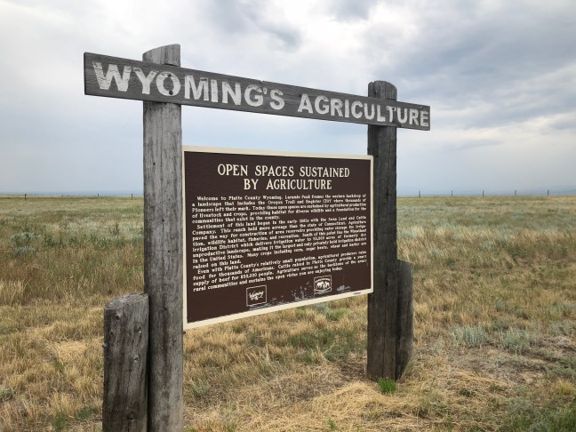
Open Spaces Sustained by Agriculture, Wyoming Historical Marker

Open Spaces Sustained by Agriculture, Wyoming Historical Marker

The open spaces in Platte County, Wyoming, are paid for by agricultural production. Wyoming can thank the introduction of agricultural mainly due to the Swan Land and Cattle Company in the 1880s. This company lasted for 68 years.

The company was founded by Alexander Swan, who may have been the best-known man in the cattle business during the early 1880. He had owned or held interest in at least 20 businesses, mainly cattle ranching.

The Swan Land and Cattle Company Ltd. was registered in Scotland on March 30, 1883. The company bought six ranches near the Chugwater and Richard and Sybille creeks in the first year. At its height, it owned 110,000 head of cattle.

However, by 1886, the price per head of cattle had fallen from its high of $40.67 in 1884 to $26.34. This resulted in now dividends being paid to shareholders. Shareholders also questioned Swan’s recordkeeping, suspecting him of fraud.

Thing also got worse during the winter of 1886 to 1887 when 15% of Wyoming cattle died due to the bad winter. Swan Land and Cattle Company had heavy losses, and Swan’s financial empire began to falter.

In May 1887, Swan was dismissed as manager by the board of directors, and the board sued Swan to try and recover costs due to exaggerated herd counts.

In 1888, John Clay Jr. was named as manager. His first move was to cut costs, including closing the Cheyenne office and moving it to Chugwater. But Clay had his own problems. He didn’t agree to cuts to his own salary, but also didn’t want to pay dividends until the company was in better shape. He was dismissed in 1896.

The troubles for the company didn’t get better. By 1904, cattle markets had significantly declined. The company instead purchased 15,000 head of sheep. Clay actually returned in 1912. But the next 15 years still had trouble with costs, and they also lost access to public lands.

The company continued on for a number of years. World War I inflation helped it make some profit. It even did rather well during the Depression during the 1930s, but Swan Land and Cattle Company Ltd. wanted to sell its assets to raise funds. But that was impossible, and the company eventually dissolved in 1951.

Historical Marker Inscription

Welcome to Platte County Wyoming. Laramie Peak frames the western backdrop of a landscape that includes the Oregon Trail and Register Cliff where thousands of Pioneers left their mark. Today these open spaces are sustained by agricultural production of livestock and crops, providing habitat for diverse wildlife and a foundation for the communities that exist in the county.

Settlement of this land began in the early 1880s with the Swan Land and Cattle Company. This ranch held more acreage than the state of Connecticut. Agriculture paved the way for construction of the area reservoirs providing water storage for irrigation, wildlife habitat, fisheries, and recreation. South of this point lies the Wheatland Irrigation District which delivers irrigation water to 55,000 acres of formerly dry unproductive landscape, making it the largest and only privately held irrigation district in the United States. Many crops including corn, sugar beets, wheat and barley are raised on this land.

Even with Platte County’s relatively small population, agricultural producers raise food for thousands of Americans. Cattle raised in Platte County provide a year’s supply of beef for 850,000 people. Agriculture serves as the backbone of the area’s rural communities and sustains the open vistas you are enjoying today.

Location

Dwyer Junction Rest Area, US-26, Wheatland, WY 82201

Intersection of U.S. 26 and Interstate 26

42° 14.008′ N, 105° 1.232′ W

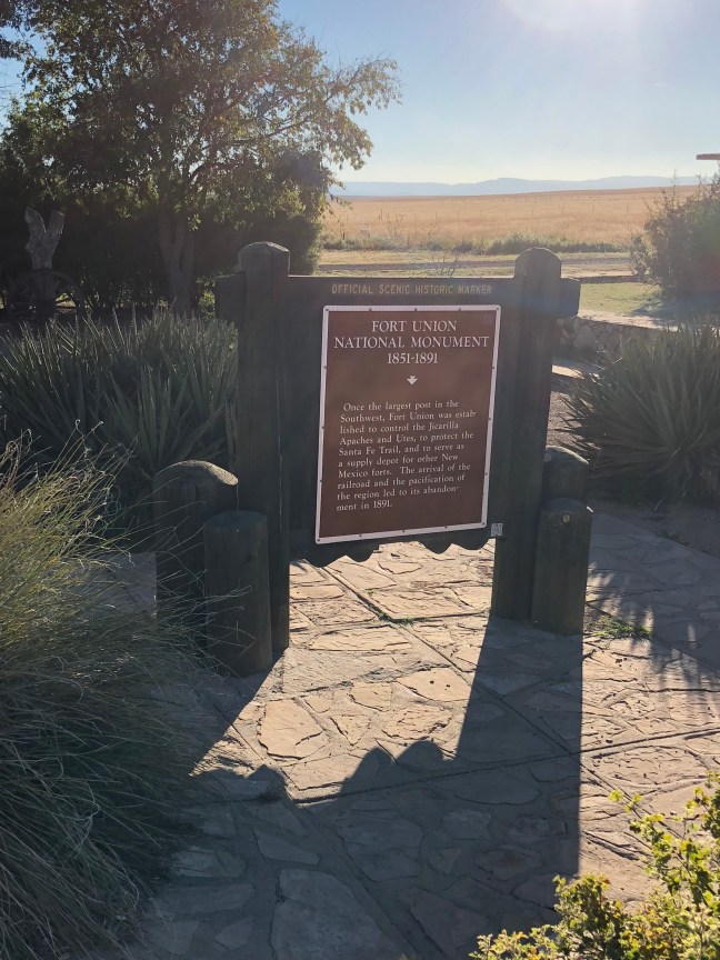
Fort Union National Monument 1851-1891

Fort Union National Monument Historical Marker, NM

Fort Union was the largest military fort in the 19th century in the American Southwest. It was established in 1851 to protect the Santa Fe Trail and lasted for 40 years. The fort was actually three different forts with the third and last fort being the largest of the three.

Fort Union acted as a military supply depot, military garrison and territorial arsenal for the entire region.

Besides the remains of the fort, visitors can also see Santa Fe Trail ruts.

Historical Marker Inscription

Once the largest post in the Southwest, Fort Union was established to control the Jicarilla Apaches and Utes, to protect the Santa Fe Trail, and to serve as a supply depot for other New Mexico forts. The arrival of the railroad and the pacification of the region led to its abandonment in 1891.

Location

35° 44′ N, 105° 2.717′ W.

Traveling North on Interstate 25, Mile Marker 360, near Las Vegas, New Mexico

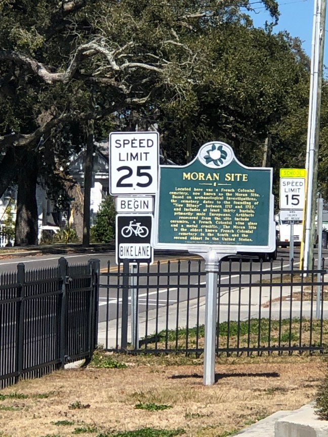
Moran Site, Biloxi, Mississippi

Moran Site, Biloxi, Mississippi

What was once a Colonial cemetery is now the French Colonial Memorial Garden, located at the Biloxi Visitors Center. The memorial park and garden commemorates the 1700s cemetery, which is the second oldest French Colonial cemetery in the United States.

The site dates back to the 1720s when Biloxi was a staging ground for European settlers and African slaves. From here, they would be relocated further into the French Louisiana Colony.

Found here were 32 graves of French Colonial settlers from the 1700s. The graves were mainly European men, and several artifacts were also discovered at this location. Remains were initially uncovered here in 1914, but it was unknown who they belong to. In 1969, Hurricane Camille unearthed more remains. A total of 12 burials were discovered at that time. Excavations post Hurricane Katrina in 2005 located an additional 20 graves.

The site is named after the Moran family who lived and worked at the site in 1952. The dedication of the memorial garden took place in 2017.

Historical Marker Inscription

Located here was a French Colonial cemetery, now known as the Moran Site. Based on archaeological investigations, the cemetery dates to the founding of “New Biloxi” between 1717 and 1722, and includes at least thirty burials, primarily male Europeans. Artifacts recovered from the site include ceramics, a French Colonial wine glass and a metal crucifix. The Moran Site is the oldest known French Colonial cemetery in the South and the second oldest in the United States.

Location

Biloxi Visitors Center, 1050 Beach Blvd, Biloxi, MS 39530

30° 23.719′ N, 88° 54.101′ W

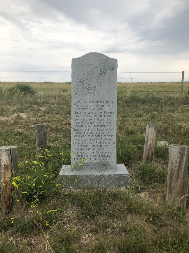
Cheyenne-Black Hills Trail, Fort Laramie, WY

Cheyenne-Black Hills Trail, Fort Laramie, WY

The Cheyenne-Black Hills Stage Route (also known as the Cheyenne-Deadwood Trail) operated between 1876 and 1887, and connected Cheyenne, Wyoming, with Deadwood, South Dakota. It was 200 miles long and was created despite a treaty which had given the Black Hills to the Sioux.

The main reason for starting the trail was that, after the discovery of gold in the Black Hills, a north-south route was needed for people, gold shipments and freight. The trail ran perpendicular to the Overland and Oregon Trails.

Many depredations occurred on the trail since there were a lot of thieves and robbers in the area as well as Sioux trying to protect their land in the Black Hills. Stagecoaches usually were escorted by armed guards. Stage stops were set up at Fort Laramie, Hat Creek Station (near Lusk and Newcastle) and Robber’s Roost. Stages would depart from Deadwood on Tuesdays and Saturdays, and from Cheyenne on Mondays and Thursdays.

Well-known icons of the time like Wild Bill Hickock, Buffalo Bill Cody and Calamity Jane were said to frequent the trail.

Historical Marker Inscription

The Cheyenne-Black Hills Trail passed near this point between 1876 and 1887. Built to supply the Dakota gold camps, the road was constructed in violation of the Ft. Laramie Treaty of 1868 which reserved the Black Hills for the Sioux Indians. Stagecoaches and wagons carrying passengers, freight and gold bullion rumbled through nearby Ft. Laramie, an important stopping point along the line, until the arrival of the Chicago and North Western Railroad rendered the route obsolete.

Erected by the Wyoming Recreation Commission
1985

Location

Located near Fort Laramie, off U.S. 26 on the north side of the road

N 42° 14.797, W 104° 34.973

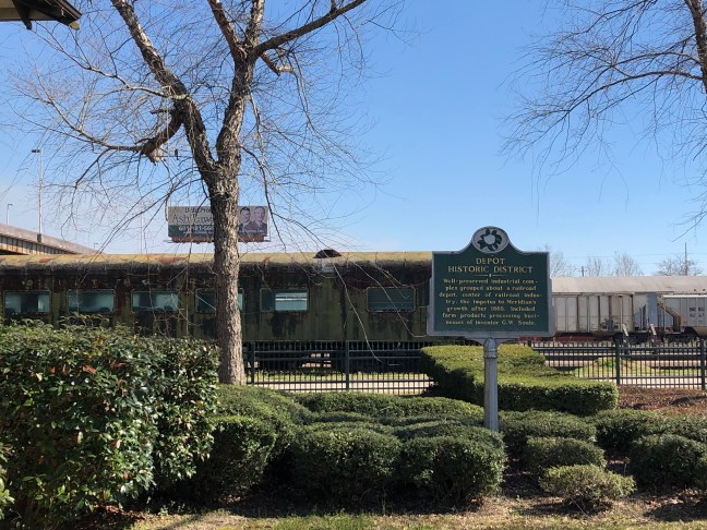
Depot Historic District, Meridian, MS

Union Stations, Meridian, MS

According to the 1907 handbook of Meridian, Mississippi, the city is called the “child of the railroad”. Starting in the 1850s, railroads starting popping up in Meridian. The Mobile and Ohio, and the Southern Railroad of Mississippi formed a junction here. The railroad was so ubiquitous to the city that even native country music star Jimmie Rodgers worked on the railroad in Meridian.

With 5 major rail lines and 44 trains running through the city on a daily basis, Meridian rose to become the largest city in the state in the 20th century. A passenger depot was completed in August 1906. The original depot was demolished in the 1940s. All that remains of the original passenger depot is the eastern wing since the rest was demoed in 1966.

The historic district takes up four city blocks along Front Street. The site is listed on the National Register of Historic Place.

Historical Marker Inscription

Well-preserved industrial complex grouped about a railroad depot, center of railroad industry, the impetus to Meridian’s growth after 1860. Included farm products processing businesses of inventor G.W. Soule.

Location

Union Station, 1901 Front St, Meridian, MS 39301

32° 21.876′ N, 88° 41.737′ W

The Dogue Indians Historical Marker, Occoquan, Virginia

The Dogue Indians Historical Marker, Occoquan, Virginia

The Dogues (also known as the Doeg) were settled at the mouth of Occoquan River when John Smith sailed up the Potomac in 1608. According to Smith, there were 40 men, and the town was named Tauxenent.

The Dogues were the scapegoat during Bacon’s Rebellion, which was caused by many different issues and led to dissent in the Virginia colony. Historians often see this as the first inclinations of what would become the American Revolution.

In July 1675, the Dogues raided the plantation of Thomas Mathews, which was located near the Potomac River. Several were killed during the raid. The colonists in retaliation attacked the wrong Native Americans, the Susquehanaugs, which resulted in large-scale Native raids.

After this time period, “Indian Land” was controlled by the Piscataway, who were located in Maryland. By 1666, this tribe was greatly weekend due to raids by the Iroquois. For protection, the Piscataway signed the Articles of Peace and Amity. with 11 other tribes. One of the tribes was the Dogues.

This marker commemorates the tribe that lived in the area.

Historical Marker Inscription

The Dogues, an Algonquian tribe, occupied the Occoquan River Watershed in the early 1600s. In their dialect, Occoquan means “at the end of the water.” They lived in villages, hunted and fished, and raised corn, beans, squash, and tobacco. They departed as the English settled the area in the 1650s. Occoquan’s Town Seal commemorates the Dogues.

Location

Mill Street in Occoquan, VA, United States

38° 41.14′ N, 77° 15.751′ W


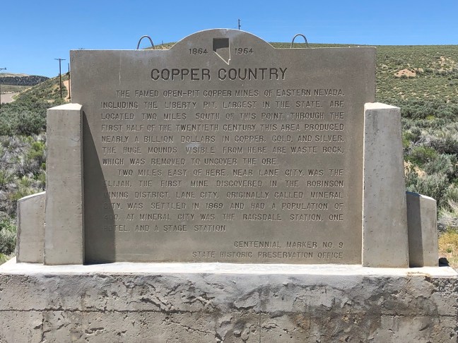
Copper Country, Nevada

Copper Country Historical Marker, Nevada

Eastern Nevada’s copper boom was known locally as the “Age of Kennecott“, after the Kennecott Copper Company, which was the world’s leader in copper output throughout much of the twentieth century.

The Liberty Pit was the largest copper mine in the state at an elevation of 7,001 feet. It started production in 1907. The ore that was mined in the area consisted of copper, chalcocite and fluorite. The minerals in the area can be traced back to the Upper Cretaceous period, which was from 100.5 to 66 million years ago.

Historical Marker Inscription

The famed open-pit copper mines of Eastern Nevada including the Liberty Pit, largest in the state, are located two miles south of this point. Through the first half of the twentieth century, this area produced nearly a billion dollars in copper, gold, and silver. The huge mounds visible from here are waste rock, which was removed to uncover the ore.

Two miles east of here, near Lane City, was the Elijah, the first mine discovered in the Robinson Mining District. Lane City, originally called Mineral City, was settled in 1869 and had a population of 400. At Mineral City was the Ragsdale Station, one hotel and a stage station.

Nevada Centennial Marker No. 9
State Historic Preservation Office

Location

Intersection of U.S. 50 and Nevada Route 267, near Ruth, Nevada

39° 17.015′ N, 114° 57.855′ W

Adams County, Gettysburg, Pennsylvania

Adams County, Pennsylvania

Gettysburg – the location of a key battle of the American Civil War – is the county seat of Adams County. The county was founded on January 22, 1800. The Battle of Gettysburg was fought between July 1 – 3, 1863.

According to the U.S. Census Bureau, the county is 522 square miles, and the Borough of Gettysburg is located at the center of the county.

Historical Marker Inscription

Formed January 22, 1800 out of York County. The name honors President John Adams. Important center of fruit growing industry. County seat of Gettysburg, incorporated 1806, was site in 1863 of key Civil War battle and President Abraham Lincoln’s great address.

Location

111 Baltimore Street, Gettysburg, PA, 17325 United States

39° 49′ 46.620″ N, 77° 13′ 52.380″

Shady Grove School/Community Building, DeRidder, LA

Shady Grove School/Community Building Historical Marker

The Shady Grove School was completed in 1953 on six acres of land, which had been donated by Roland and Ida Pompey. The school was created to centralize the education of African American children in the Vernon, Louisiana, and the surrounding communities. The school hosted children in grades first through eighth.

The elementary school was active until 1969 when sections were moved to the newly established Vernon Elementary School. Afterwards, the site was given to the City of Vernon, and it is now a public park named Shady Grove Park.

Shady Grove School/Community Building (2)

Historical Marker Inscription

Built 1919 – used as a school until 1928. Bought by community families to be used for cultural and social activities. Placed on the National Register of Historic Places December 2002.

Location

Intersection of State Highway 26 and Don Gray Road, DeRidder, Louisiana

30° 48.254′ N, 93° 10.494′ W.

City of Eunice, LA, Historical Marker

City of Eunice, Louisiana, Historical Marker

The City of Eunice, Louisiana, is located in St. Landry Parish, and it is considered to be a part of the Lafayette Metropolitan area. The city was founded by C.C. Duson, who named the area after his second wife. Duson had previously founded Crowley, LA, as well.

As part of his founding the area, he added 160 acres to the town, and Duson was also responsible for linking Eunice to the Southern Pacific Railroad. The village was officially chartered on September 12, 1894, and it was later reincorporated on June 4, 1895.

Eunice is considered the “prairie” Cajun capital of Louisiana.

Historical Marker Inscription

On this site C.C. Duson drove a stake and said: “On this spot I will build a town and name it for my wife, Eunice.” An auction of lots was held here to start the town, Sept. 12, 1894. Depot listed on the National Register of Historic Places.

Location

Located near 220 S CC Duson St, Eunice, LA 70535

30° 29.589′ N, 92° 24.906′ W